|
|
| Mesoscale Discussion 1974 | |
| < Previous MD | |

|
|
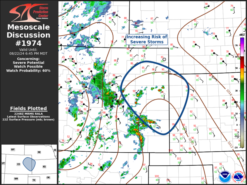
Mesoscale Discussion 1974 NWS Storm Prediction Center Norman OK 0551 PM CDT Thu Aug 22 2024 Areas affected...Central High Plains Concerning...Severe potential...Watch possible Valid 222251Z - 230045Z Probability of Watch Issuance...60 percent SUMMARY...Convection is expected to increase in areal coverage across the central High Plains over the next few hours. Hail/wind are possible with these storms as they spread across eastern Colorado toward northwest Kansas. DISCUSSION...Strong surface heating has contributed to very steep 0-3km lapse rates across eastern Colorado. Scattered robust convection has developed off the higher terrain which is now propagating over lower elevations where temperatures remain in the 90s. Over the next few hours, this activity will spread into a corridor of somewhat stronger low-level convergence characterized by higher boundary-layer moisture and stronger instability. Diagnostic data suggests MLCAPE values are near 2000 J/kg near the CO/KS border where surface dew points are holding above 60F. While satellite imagery does not explicitly reflect any short-wave troughs, modest 500mb southwesterly flow does extend across this region and 0-6km bulk shear is at least 30kt. This environment is supportive of supercells and ongoing activity should continue to grow upscale into the early evening. With time, LLJ is forecast to increase across the TX Panhandle into western KS so a larger complex of storms could emerge. Hail/wind are the primary threats. ..Darrow/Gleason.. 08/22/2024 ...Please see www.spc.noaa.gov for graphic product... ATTN...WFO...DDC...GLD...PUB...BOU... LAT...LON 39290438 40480325 39570110 37690229 39290438 |
|
|
Top/All Mesoscale Discussions/Forecast Products/Home |
|


