| Mesoscale Discussion 196 | |
| < Previous MD Next MD > | |

|
|
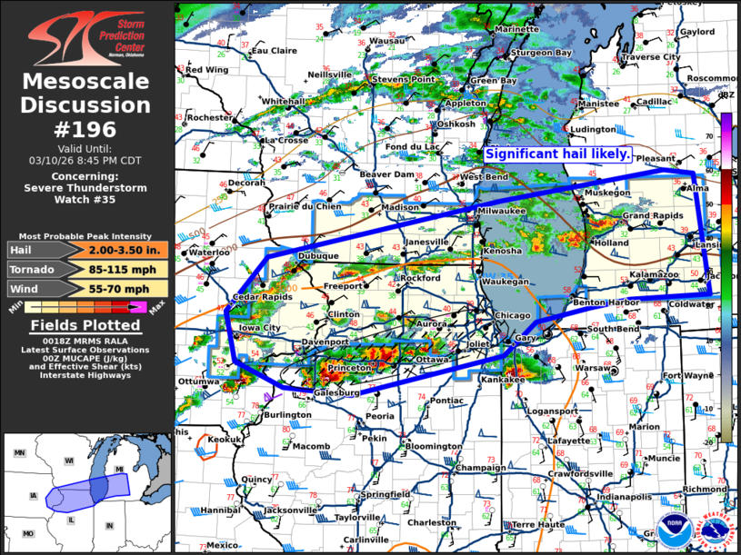
Mesoscale Discussion 0196 NWS Storm Prediction Center Norman OK 0721 PM CDT Tue Mar 10 2026 Areas affected...eastern Iowa northern Illinois far southern Wisconsin into southern Lower Michigan Concerning...Severe Thunderstorm Watch 35... Valid 110021Z - 110145Z The severe weather threat for Severe Thunderstorm Watch 35 continues. SUMMARY...Numerous supercells will remain capable of significant hail this evening. Damaging gusts may also be possible as storms conglomerate tonight. DISCUSSION...As of 0015 UTC, regional radar imagery showed numerous thunderstorms ongoing along and north of the warm frontal zone into parts of IA/IL/WI and MI. Most of these storms are on the cool side of the boundary and will remain so this evening. Robust MUCAPE (1000-2000J/kg) and strong deep-layer shear will continue to support strong supercells over much of WW35. Given the degree of buoyancy large hail is likely. Isolated very large hail is also possible with more intense cluster of supercells on the immediate cool side of the warm front in northern IL as well. With time, upscale growth into small bowing segments with some potential for damaging gusts is expected tonight. The severe risk should continue to increase over much of WW35 this evening. WW35 has been locally extended farther east across portions of the GRR CWA. ..Lyons.. 03/11/2026 ...Please see www.spc.noaa.gov for graphic product... ATTN...WFO...DTX...IWX...GRR...LOT...ILX...MKX...DVN...ARX... LAT...LON 41929170 42559109 43228751 43538498 43488451 42118433 42088555 41988617 41838698 41468748 41258850 40998978 41069080 41349154 41929170 MOST PROBABLE PEAK TORNADO INTENSITY...85-115 MPH MOST PROBABLE PEAK WIND GUST...55-70 MPH MOST PROBABLE PEAK HAIL SIZE...2.00-3.50 IN |
|
|
Top/All Mesoscale Discussions/Forecast Products/Home |
|
Source link