| Mesoscale Discussion 195 | |
| < Previous MD | |

|
|
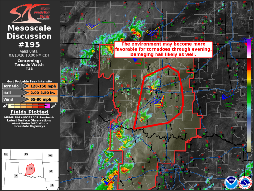
Mesoscale Discussion 0195 NWS Storm Prediction Center Norman OK 0653 PM CDT Tue Mar 10 2026 Areas affected...much of central Oklahoma Concerning...Tornado Watch 33... Valid 102353Z - 110300Z The severe weather threat for Tornado Watch 33 continues. SUMMARY...The environment is becoming more favorable for tornadoes along and east of I-35 in Oklahoma, along with damaging hail threat. DISCUSSION...A supercell is currently moving across eastern Canadian into Oklahoma County, with another supercell currently over Cotton moving into Stephens County. Given the discrete nature of these cells, they will likely continue to pose a destructive hail and tornado threat for several hours and they approach and move across the I-35 corridor. The latest TLX VWP is showing a gradual increase in low-level shear, with 0-1 SRH now over 150 m2/s2. The OK Mesonet shows more robust dewpoints generally along and south of a line from CHK to SNL with 65 to 67 F. As such, over the next few hours, the low-level shear and environment in general should continue to favor supercells with both tornado and large hail risk, as these cells move across I-35. A potentially even greater tornado risk could develop in the 00-03Z time frame as the low-level jet increases. ..Jewell.. 03/10/2026 ...Please see www.spc.noaa.gov for graphic product... ATTN...WFO...TSA...OUN... LAT...LON 34149850 35919809 36299708 36089666 35579651 35019646 34709657 34369709 34149850 MOST PROBABLE PEAK TORNADO INTENSITY...120-150 MPH MOST PROBABLE PEAK WIND GUST...65-80 MPH MOST PROBABLE PEAK HAIL SIZE...2.00-3.50 IN |
|
|
Top/All Mesoscale Discussions/Forecast Products/Home |
|
Source link