|
|
| Mesoscale Discussion 1945 | |
| < Previous MD | |

|
|
   Mesoscale Discussion 1945
   NWS Storm Prediction Center Norman OK
   0158 PM CDT Sun Aug 18 2024

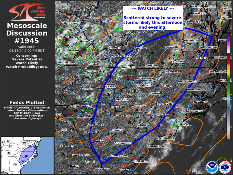
   Areas affected...Central/Southern Virginia and the Carolinas

   Concerning...Severe potential...Watch likely

   Valid 181858Z - 182100Z

   Probability of Watch Issuance...80 percent

   SUMMARY...Scattered strong to severe storms are likely this
   afternoon and evening.

   DISCUSSION...Visible satellite trends show deepening cu across much
   of the region from central/southern Virginia southward into the
   Carolinas. Thunderstorm development is likely to begin in these
   regions over the next 1-2 hours. A few cells have developed across
   western North Carolina near the higher terrain. The air mass east of
   this development is characterized by MLCAPE around 1000-2000 J/kg
   with temperatures in the upper 80s-90s and dew points in the low to
   mid 70s. This moist and unstable air mass will support multicell
   clusters capable of downbursts. A watch will likely be needed to
   cover this threat soon.

   ..Thornton/Hart.. 08/18/2024

   ...Please see www.spc.noaa.gov for graphic product...

   ATTN...WFO...AKQ...MHX...LWX...RAH...ILM...RNK...CHS...CAE...
   GSP...

   LAT...LON   33378181 33688201 33978199 35348160 36008126 36708076
               37018039 37337988 37577930 37967789 38127730 37957664
               37767606 37717601 35957705 34207883 32728138 33378181
|
|
|
Top/All Mesoscale Discussions/Forecast Products/Home |
|


