|
|
| Mesoscale Discussion 1940 | |
| < Previous MD | |

|
|
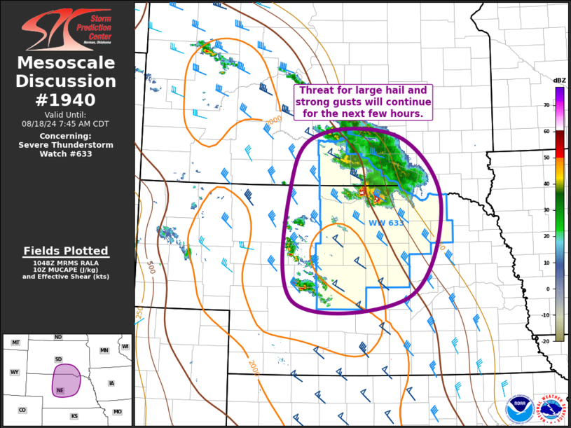
Mesoscale Discussion 1940 NWS Storm Prediction Center Norman OK 0550 AM CDT Sun Aug 18 2024 Areas affected...South-Central SD...North-Central/Central NE Concerning...Severe Thunderstorm Watch 633... Valid 181050Z - 181245Z The severe weather threat for Severe Thunderstorm Watch 633 continues. SUMMARY...Threat for large hail and strong gusts will continues across far south-central South Dakota and north-central/central Nebraska for the next few hours. DISCUSSION...Lead supercell within the elevated cluster of showers and thunderstorms extending from central SD into far north-central NE has maintained its intensity over the past hour while much of the other convection has weakened. Organized character of this storm suggests it will remain strong as it continues southeastward into more of north-central NE over the next hour or so. Thereafter, displacement from the warm-air advection responsible of this storm's initiation could result in a gradual weakening. Until this weakening begins, both large hail and strong gusts are possible with this storm. Farther southwest (i.e. across central NE), elevated thunderstorms continue to push eastward into central NE. These storms developed along the leading edge of the greater large-scale forcing for ascent attendant to a shortwave trough emerging into the central High Plains. Despite moderate buoyancy, these storms have been slow to strengthen. Some strengthening is possible over the next hour or so as forcing for ascent persists and vertical shear increases slightly. Large hail is the primary risk with these storms. ..Mosier.. 08/18/2024 ...Please see www.spc.noaa.gov for graphic product... ATTN...WFO...FSD...OAX...ABR...GID...LBF...UNR... LAT...LON 43830005 43739840 42689760 41229830 41160076 43180075 43830005 |
|
|
Top/All Mesoscale Discussions/Forecast Products/Home |
|


