|
|
| Mesoscale Discussion 1931 | |
| < Previous MD | |

|
|
   Mesoscale Discussion 1931
   NWS Storm Prediction Center Norman OK
   1252 PM CDT Sat Aug 17 2024

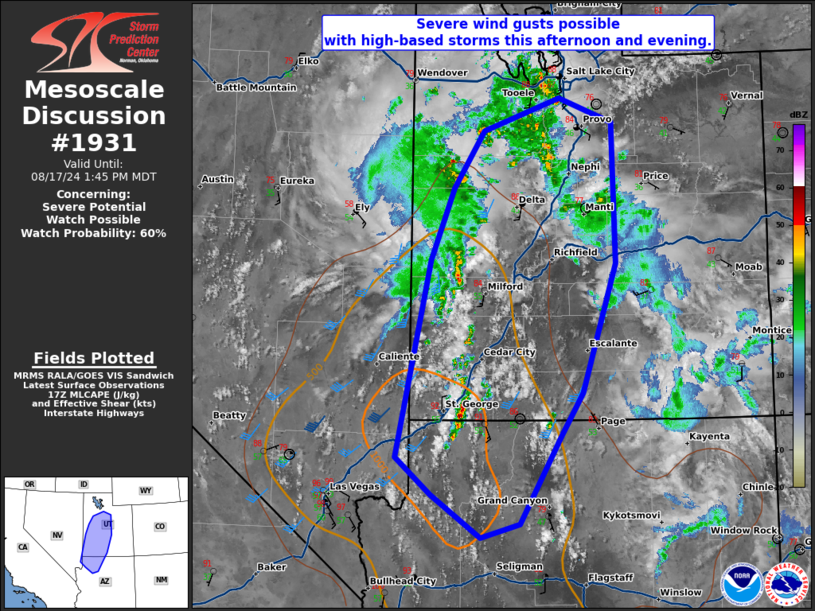
   Areas affected...northwest Arizona to north-central Utah

   Concerning...Severe potential...Watch possible

   Valid 171752Z - 171945Z

   Probability of Watch Issuance...60 percent

   SUMMARY...Severe wind gusts are possible with high-based storms this
   afternoon and evening from northwest Arizona to north-central Utah.

   DISCUSSION...Numerous elevated thunderstorms developed earlier this
   morning on the leading edge of a northward surge of monsoon
   moisture. In the wake of this convection, clear skies have allowed
   for sufficient surface heating which, when combined with the
   increasing low-level moisture, has resulted in moderate
   destabilization. SPC mesoanalysis suggests inhibition has mostly
   eroded. Therefore, surface-based storms, with likely a greater
   severe wind threat, are possible within the next 1 to 2 hours as
   further warming/moistening occurs. An environment this afternoon
   featuring high-based storms and a deeply-mixed boundary layer with
   1000-1500 J/kg MLCAPE and 25-30 knots of effective shear should
   support some threat for severe wind gusts. With multiple rounds of
   storms possible, a severe thunderstorm watch may be needed to
   address this threat.

   ..Bentley/Hart.. 08/17/2024

   ...Please see www.spc.noaa.gov for graphic product...

   ATTN...WFO...FGZ...SLC...VEF...

   LAT...LON   36591423 38751377 39551345 40181302 40531196 40271123
               38711119 37291165 36821196 35861252 35711307 36181375
               36591423
|
|
|
Top/All Mesoscale Discussions/Forecast Products/Home |
|


