|
|
| Mesoscale Discussion 1923 | |
| < Previous MD | |

|
|
   Mesoscale Discussion 1923
   NWS Storm Prediction Center Norman OK
   0531 PM CDT Fri Aug 16 2024

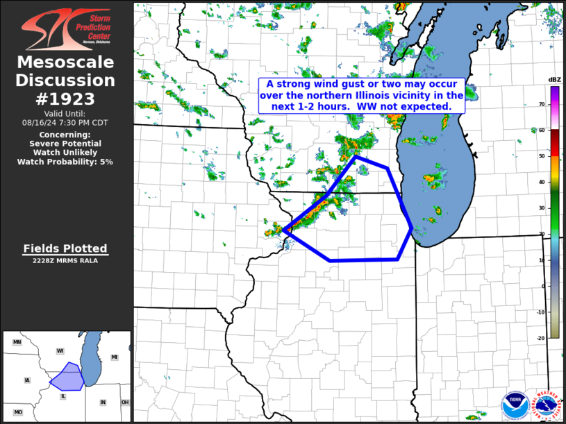
   Areas affected...southeastern Wisconsin and northern Illinois

   Concerning...Severe potential...Watch unlikely

   Valid 162231Z - 170030Z

   Probability of Watch Issuance...5 percent

   SUMMARY...Gusty winds locally -- with potential for a gust or two
   near severe levels -- can be expected over the next couple of hours
   across a portion of far southeastern Wisconsin and into northern
   Illinois.  WW issuance is not expected, due to anticipated
   marginal/isolated nature of the risk.

   DISCUSSION...Latest radar loop shows that a semi-organized band of
   storms has developed over northwestern Illinois, ahead of a subtle,
   eastward-moving mid-level vort max embedded within the cyclonic flow
   surrounding the western Lake Superior upper low.  A narrow axis of
   1500 J/kg mixed-layer CAPE is indicated just ahead of the band of
   storms, which suggests continuation -- and possible/slight
   strengthening over the next 1 to 2 hours.

   The latest VWP from the KLOT (Chicago, IL) WSR-88D shows flow weakly
   veering from west-southwesterly to west-northwesterly with height,
   and increasing to around 35 kt at mid levels.  This should allow
   storms to progress into the Chicago -- and possibly Milwaukee --
   vicinity, accompanied by gusty winds.  While a couple of gusts could
   near or reach severe levels, risk should remain sparse and marginal,
   and thus insufficient to warrant WW consideration.

   ..Goss/Edwards.. 08/16/2024

   ...Please see www.spc.noaa.gov for graphic product...

   ATTN...WFO...LOT...MKX...DVN...

   LAT...LON   41899033 42458943 43088879 42888810 41938760 41438790
               41418935 41899033
|
|
|
Top/All Mesoscale Discussions/Forecast Products/Home |
|


