|
|
| Mesoscale Discussion 1910 | |
| < Previous MD | |

|
|
   Mesoscale Discussion 1910
   NWS Storm Prediction Center Norman OK
   0401 PM CDT Thu Aug 15 2024

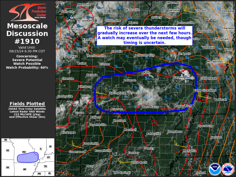
   Areas affected...Portions of southern Missouri into southern
   Illinois

   Concerning...Severe potential...Watch possible

   Valid 152101Z - 152330Z

   Probability of Watch Issuance...60 percent

   SUMMARY...The risk of severe thunderstorms capable of damaging winds
   and large hail will gradually increase over the next few hours. A
   watch may eventually be needed, though timing is uncertain.

   DISCUSSION...Latest mesoanalysis and VWP data indicate weak
   low-level warm advection atop an antecedent outflow boundary across
   portions of southern MO into southern IL -- where cumulus clouds are
   gradually evolving/deepening. Continued diurnal heating and warm
   advection should eventually support thunderstorm development across
   the area, though the weak forcing for ascent casts uncertainty on
   timing of initiation. That said, one thunderstorm has developed on
   the southern MO/IL border, and this storm could pose a risk of
   locally damaging gusts and marginally severe hail in the near term.

   Additional thunderstorms will be developing in an environment
   characterized by around 30 kt of effective shear (with favorable
   low-level hodograph curvature) and steep midlevel lapse rates atop a
   warm/moist boundary layer (middle 70s dewpoints and upper 80s/lower
   90s temperatures). As a result, a mix of organized clusters and
   supercells are possible, posing a risk of damaging winds and large
   hail. Westerly flow parallel to the antecedent outflow may promote
   gradual congealing of cold pools and an increasing risk of severe
   gusts. While a watch may eventually be needed for parts of the area,
   timing is currently uncertain.

   ..Weinman/Thompson.. 08/15/2024

   ...Please see www.spc.noaa.gov for graphic product...

   ATTN...WFO...PAH...LSX...SGF...

   LAT...LON   38069209 38329076 38369021 38228963 37908939 37298940
               36908957 36678993 36589121 36599282 36629352 36819386
               37139391 37559391 37859358 38069209
|
|
|
Top/All Mesoscale Discussions/Forecast Products/Home |
|


