|
|
| Mesoscale Discussion 1896 | |
| < Previous MD | |

|
|
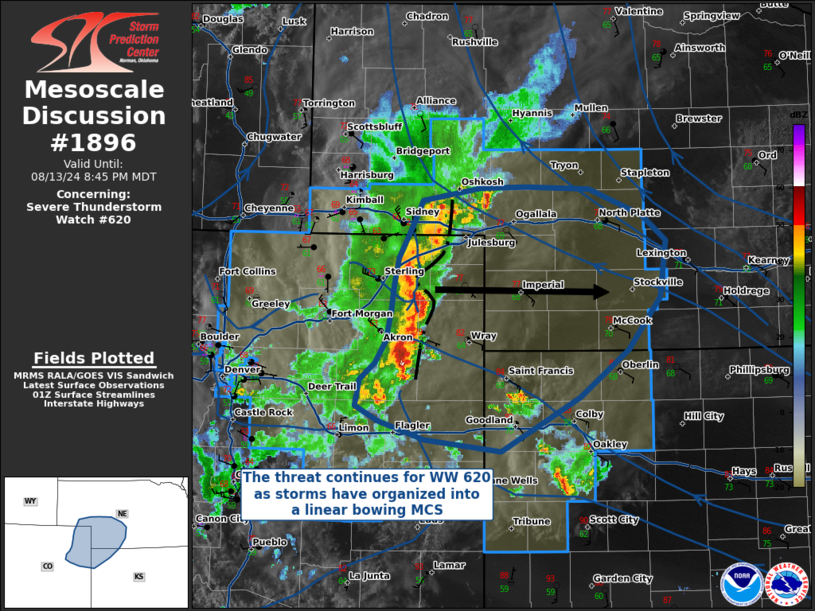
Mesoscale Discussion 1896 NWS Storm Prediction Center Norman OK 0818 PM CDT Tue Aug 13 2024 Areas affected...Eastern Colorado...Northwestern Kansas...and Southwestern Nebraska Concerning...Severe Thunderstorm Watch 620... Valid 140118Z - 140245Z The severe weather threat for Severe Thunderstorm Watch 620 continues. SUMMARY...The threat continues for WW 620, where thunderstorms have organized into a linear bowing MCS capable of damaging winds. DISCUSSION...Thunderstorms have grown upscale into a linear-bowing MCS, moving eastward off the High Plains and into northwestern Kansas and southwestern Nebraska. Reports of 60-70 MPH winds have been associated with this complex, and it is moving into an environment with stronger CAPE/shear combinations that should result in further intensification. Additionally, surface flow ahead of the MCS is nearly perpendicular to the outflow boundary/cold pool, which should aid in maintaining upright convection and maintain MCS intensity with eastward extent. The greatest threat for damaging winds will be at the apex of any bowing segments, especially if a rear inflow jet is able to develop. While the primary threat will be for damaging winds, some brief tornadoes cannot be ruled out due to significant curvature of the low-level hodographs evident in recent KGLD VAD wind profiles, where 0-1 km SRH and 0-3 km SRH have increased to 148 m^2/s^2 and 318 m^2/s^2, respectively. ..Halbert/Wendt.. 08/14/2024 ...Please see www.spc.noaa.gov for graphic product... ATTN...WFO...GID...LBF...GLD...BOU...CYS... LAT...LON 39220271 39390324 39520349 39740344 39880327 40070315 40340309 40560306 40800302 41070287 41300274 41410208 41410157 41390085 41170025 40959999 40450006 40000041 39590096 39310149 39130186 39220271 |
|
|
Top/All Mesoscale Discussions/Forecast Products/Home |
|


