|
|
| Mesoscale Discussion 1890 | |
| < Previous MD | |

|
|
   Mesoscale Discussion 1890
   NWS Storm Prediction Center Norman OK
   0826 PM CDT Mon Aug 12 2024

   Areas affected...Eastern Colorado into Western Kansas...and the far
   western Texas and Oklahoma Panhandles

   Concerning...Severe potential...Watch unlikely

   Valid 130126Z - 130330Z

   Probability of Watch Issuance...20 percent

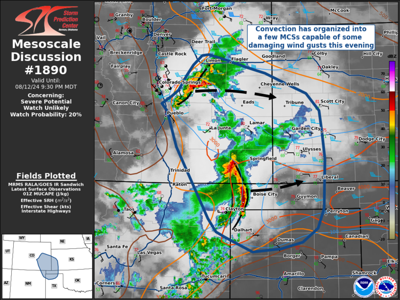
   SUMMARY...Convection has organized into a few linear segments as
   storms have progressed eastward onto the High Plains of eastern
   Colorado and the far northwestern TX/western OK Panhandles. These
   storms could be capable of a few severe gusts, but are moving into a
   stabilizing environment. Weather Watch issuance is not likely at
   this time.

   DISCUSSION...Afternoon thunderstorms have begun to coalesce into two
   linear convective segments -- one in eastern Colorado, the other in
   the far western Oklahoma Panhandle -- that will be capable of a few
   severe gusts this evening. The greatest threat for severe winds will
   be along the leading edge of any developing bow echoes, though the
   stabilizing nocturnal boundary-layer could inhibit some of the
   higher-momentum air from reaching the surface. Additionally, the
   observed 00Z DDC sounding, along with SPC mesoanalysis, suggests
   both MCSs are moving into increasing MUCINH that will likely cause
   convection to weaken with eastward extent. Given these factors,
   Weather Watch issuance appears unlikely at this time.

   ..Halbert/Wendt/Edwards.. 08/13/2024

   ...Please see www.spc.noaa.gov for graphic product...

   ATTN...WFO...DDC...GLD...AMA...PUB...BOU...ABQ...

   LAT...LON   35690251 35850286 35980317 36080337 36330357 37670434
               38360458 38500470 38640445 38760430 39040412 39240396
               39410374 39430358 39340317 39200269 39090222 38860163
               38700123 38370091 37950086 37440079 37000081 36510084
               36130098 35870134 35750184 35690251
|
|
|
Top/All Mesoscale Discussions/Forecast Products/Home |
|


