| Mesoscale Discussion 188 | |
| < Previous MD Next MD > | |

|
|
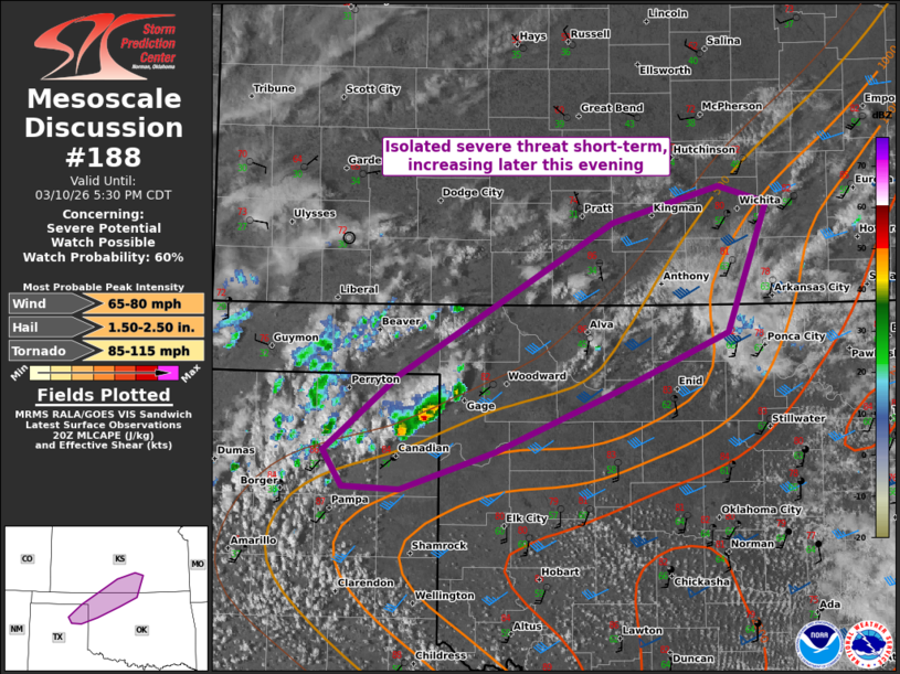
   Mesoscale Discussion 0188
   NWS Storm Prediction Center Norman OK
   0334 PM CDT Tue Mar 10 2026

   Areas affected...in the northeast TX Panhandle...northwest OK...and
   south-central KS

   Concerning...Severe potential...Watch possible

   Valid 102034Z - 102230Z

   Probability of Watch Issuance...60 percent

   SUMMARY...Isolated severe wind and marginally severe hail are
   possible in the short-term across the northeast Texas Panhandle. The
   severe threat should increase this evening, with a corridor of
   supercell clustering towards south-central Kansas.

   DISCUSSION...Rather high-based and isolated storm development has
   occurred across the TX Panhandle over the past couple hours.
   Convection should further increase and eventually consolidate over
   the northeast Panhandle into northwest OK, in advance of the
   northern lobe of the broader shortwave trough over the southern High
   Plains. A strengthening low-level jet into early evening should
   support a northward advancement of progressively richer low-level
   moisture across much of the body of OK. This should support an
   uptick in convective intensity as storms impinge on this increasing
   moisture, evolving along the quasi-stationary
   southwest/northeast-oriented front into south-central KS.

   The initial severe threat should remain mainly isolated and
   marginal. But the expected strengthening of storms during the
   evening could support increasing peak intensities, along with a
   confined corridor of severe storms into south-central KS.

   ..Grams/Gleason.. 03/10/2026

   ...Please see www.spc.noaa.gov for graphic product...

   ATTN...WFO...ICT...OUN...DDC...AMA...

   LAT...LON   35950102 36490035 37599845 37859750 37739707 36799742
               36399836 35949951 35660035 35680085 35950102

   MOST PROBABLE PEAK TORNADO INTENSITY...85-115 MPH
   MOST PROBABLE PEAK WIND GUST...65-80 MPH
   MOST PROBABLE PEAK HAIL SIZE...1.50-2.50 IN
|
|
|
Top/All Mesoscale Discussions/Forecast Products/Home |
|
Source link