|
|
| Mesoscale Discussion 1868 | |
| < Previous MD | |

|
|
   Mesoscale Discussion 1868
   NWS Storm Prediction Center Norman OK
   0221 PM CDT Thu Aug 08 2024

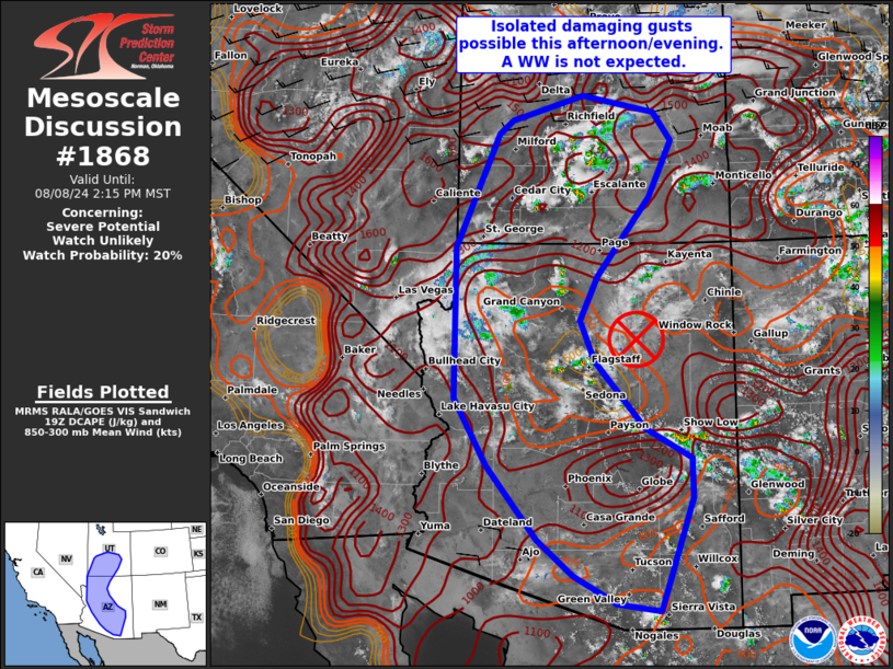
   Areas affected...Southern Utah into western and central Arizona

   Concerning...Severe potential...Watch unlikely

   Valid 081921Z - 082115Z

   Probability of Watch Issuance...20 percent

   SUMMARY...Scattered high-based thunderstorms are likely near the
   higher terrain and ahead of a weak MCV this afternoon/evening.
   Isolated damaging gusts are possible. Limited storm organization
   suggests a WW is not expected.

   DISCUSSION...As of 1915 UTC, regional visible and radar imagery
   showed initial thunderstorm development was ongoing over the higher
   terrain of southern UT and across central AZ. Linked to robust
   monsoonal moisture return and an MCV beneath an expansive western US
   ridge, additional storm development is likely through the afternoon
   hours. As remaining inhibition weakens, 500-1000 J/kg of MUCAPE will
   support scattered high-based thunderstorms across the higher terrain
   of southern UT and ahead of a weak MCV over central AZ. PWATs of
   0.7-1 inch and relatively deep inverted-V profiles from area model
   soundings will favor strong downdrafts with some potential for
   damaging outflow winds as storms become established.
   However, area VADs show flow aloft is quite limited (generally less
   than 20 kt) beneath the ridge. Given the limited shear, a relatively
   disorganized multi-cell storm mode is expected to limit the severe
   risk. Given the limited organization potential a WW is unlikely at
   this time.

   ..Lyons/Hart.. 08/08/2024

   ...Please see www.spc.noaa.gov for graphic product...

   ATTN...WFO...TWC...FGZ...SLC...PSR...VEF...

   LAT...LON   36931405 38611328 38801303 39171174 38921043 38511012
               37671053 36511149 35871180 35261154 34271065 33840984
               33250982 31601041 31711119 31821138 32121193 32641257
               33731347 34721405 36931405
|
|
|
Top/All Mesoscale Discussions/Forecast Products/Home |
|


