| Mesoscale Discussion 180 | |
| < Previous MD | |

|
|
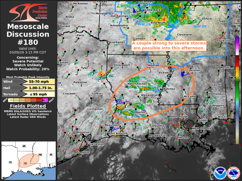
   Mesoscale Discussion 0180
   NWS Storm Prediction Center Norman OK
   0112 PM CDT Mon Mar 09 2026

   Areas affected...Parts of LA into southwest MS

   Concerning...Severe potential...Watch unlikely

   Valid 091812Z - 092015Z

   Probability of Watch Issuance...20 percent

   SUMMARY...A couple strong to severe storms may pose a risk of
   damaging gusts, marginal hail, and perhaps a localized/brief tornado
   risk.

   DISCUSSION...Within a zone of broad/weak low-level warm advection in
   southern/central LA, diurnal heating amid lower 70s dewpoints is
   aiding in destabilization and removal of inhibition. As a result, a
   modest uptick in thunderstorm strength and coverage has occurred
   over the last 30 minutes or so. While the lingering inhibition and
   generally weak large-scale forcing for ascent cast uncertainty on
   thunderstorm intensification/longevity, around 30-40 kt of effective
   shear (stronger with northward extent) and small clockwise-curved
   low-level hodographs may support a couple loosely organized storms
   through the afternoon. The stronger/longer-lived storms will pose a
   risk of locally damaging gusts and marginally severe hail, though
   the moist boundary layer and low-level streamwise vorticity may
   support a localized/brief tornado risk as well. Current thinking is
   that the severe risk will remain too localized for a watch, though
   trends are being monitored.

   ..Weinman/Thompson.. 03/09/2026

   ...Please see www.spc.noaa.gov for graphic product...

   ATTN...WFO...JAN...LIX...LCH...SHV...

   LAT...LON   30829390 31129382 31549363 32029315 32569198 32579101
               32429025 32158998 31858993 31489003 31009053 30439229
               30389313 30509363 30829390

   MOST PROBABLE PEAK TORNADO INTENSITY...UP TO 95 MPH
   MOST PROBABLE PEAK WIND GUST...55-70 MPH
   MOST PROBABLE PEAK HAIL SIZE...1.00-1.75 IN
|
|
|
Top/All Mesoscale Discussions/Forecast Products/Home |
|
Source link