| Mesoscale Discussion 178 | |
| < Previous MD | |
|
|
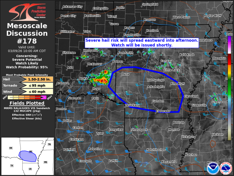
   Mesoscale Discussion 0178
   NWS Storm Prediction Center Norman OK
   0832 AM CDT Mon Mar 09 2026

   Areas affected...Parts of southern Arkansas

   Concerning...Severe potential...Watch likely

   Valid 091332Z - 091500Z

   Probability of Watch Issuance...95 percent

   SUMMARY...Risk of severe hail and perhaps locally damaging gusts
   will continue spreading eastward across southern Arkansas into this
   afternoon. A watch will be issued shortly.

   DISCUSSION...A cluster of elevated splitting supercells is ongoing
   across far southeastern OK this morning, which is being aided by
   large-scale forcing for ascent ahead of a low-amplitude midlevel
   impulse and broad/weak low-level warm advection. As the impulse
   continues eastward, these storms (and additional development) will
   continue eastward across southern AR into this afternoon. Around 40
   to 50 kt of midlevel flow (per nearby VWP) and steep midlevel lapse
   rates will favor large hail with primarily elevated supercells.
   Diurnal heating may eventually support surface-based storms, with an
   increase in the damaging-wind risk, as this activity continues
   eastward. A watch will be issued shortly for southern AR.

   ..Weinman/Thompson.. 03/09/2026

   ...Please see www.spc.noaa.gov for graphic product...

   ATTN...WFO...JAN...LZK...SHV...TSA...

   LAT...LON   33439378 33779431 34199478 34719459 34919416 34929358
               34699231 34349166 33839141 33249162 33239241 33439378

   MOST PROBABLE PEAK TORNADO INTENSITY...UP TO 95 MPH
   MOST PROBABLE PEAK WIND GUST...UP TO 60 MPH
   MOST PROBABLE PEAK HAIL SIZE...1.50-2.50 IN
|
|
|
Top/All Mesoscale Discussions/Forecast Products/Home |
|
Source link