| Mesoscale Discussion 172 | |
| < Previous MD | |

|
|
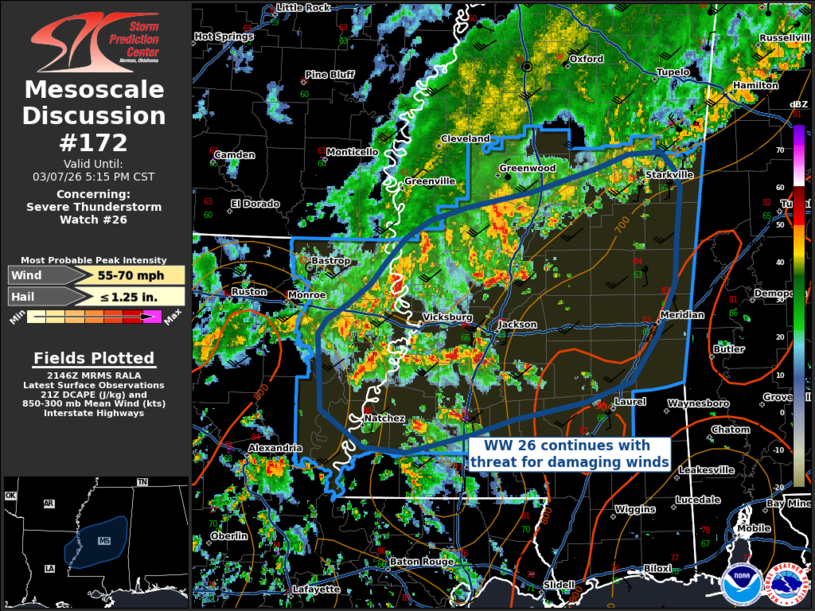
Mesoscale Discussion 0172 NWS Storm Prediction Center Norman OK 0349 PM CST Sat Mar 07 2026 Areas affected...Northeastern Louisiana into Central Mississippi Concerning...Severe Thunderstorm Watch 26... Valid 072149Z - 072315Z The severe weather threat for Severe Thunderstorm Watch 26 continues. SUMMARY...The threat for damaging thunderstorm winds continues across WW 26 until 03 UTC. DISCUSSION...Thunderstorms in WW 26 will continue across the area, posing a threat primarily for damaging straight-line winds. Thunderstorms associated with a convectively-modified cold front moving east-southeast is going to intersect with warm sector convection moving northward. These warm sector storms have developed in a relatively dry boundary layer with inverted-v profiles supporting downbursts/damaging wind gusts. An additional, localized threat for damaging winds may materialize where thunderstorm/outflow interactions occur over the next few hours. ..Halbert.. 03/07/2026 ...Please see www.spc.noaa.gov for graphic product... ATTN...WFO...MEG...JAN...LIX... LAT...LON 31679178 32269181 32379173 32439166 32509155 32669133 32839119 33019101 33159078 33259045 33378985 33508946 33568925 33668896 33698866 33568853 33398848 33008852 32678853 32268869 31908894 31748938 31619002 31499040 31349101 31389139 31679178 MOST PROBABLE PEAK WIND GUST...55-70 MPH MOST PROBABLE PEAK HAIL SIZE...UP TO 1.25 IN |
|
|
Top/All Mesoscale Discussions/Forecast Products/Home |
|
Source link