|
|
| Mesoscale Discussion 1713 | |
| < Previous MD | |

|
|
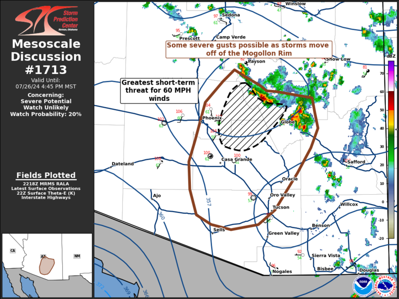
   Mesoscale Discussion 1713
   NWS Storm Prediction Center Norman OK
   0521 PM CDT Fri Jul 26 2024

   Areas affected...Central and Southern Arizona

   Concerning...Severe potential...Watch unlikely

   Valid 262221Z - 262345Z

   Probability of Watch Issuance...20 percent

   SUMMARY...Some severe gusts are possible as storms move off of the
   higher terrain into an environment characterized by hot and dry
   boundary-layer profiles. Due to the isolated nature of this
   convection, watch issuance appears unlikely at this time.

   DISCUSSION...Storms that developed this afternoon on the Mogollon
   Rim have begun to move into southern Arizona and the lower terrain,
   where hot and dry boundary layer profiles will support gusty
   thunderstorm outflow capable of 60 MPH winds.

   The greatest chances for severe wind gusts will be with the most
   intense convective cores moving towards the eastern portions of
   Phoenix, where some loose organization of outflow into a bowing
   segment has been observed.

   Further southeast near Tuscon, surface observations show cooler and
   drier air, resulting in a relative minima of ML/MUCAPE. Any storms
   that move into this environment may decrease in intensity more
   quickly than western portions of the risk area.

   ..Halbert/Weinman/Hart.. 07/26/2024

   ...Please see www.spc.noaa.gov for graphic product...

   ATTN...WFO...TWC...FGZ...PSR...

   LAT...LON   34061133 33931110 33861099 33861084 33841070 33801051
               33771024 33571020 33351016 33081028 32731050 32221087
               32031113 31951157 32021189 32161213 32501225 32891226
               33181217 33701200 34001172 34161153 34061133
|
|
|
Top/All Mesoscale Discussions/Forecast Products/Home |
|