|
|
| Mesoscale Discussion 1708 | |
| < Previous MD | |

|
|
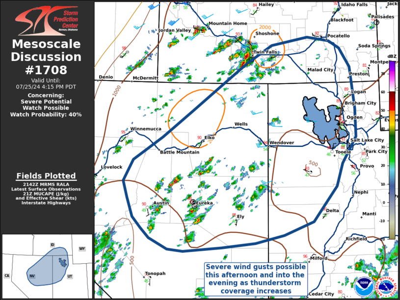
   Mesoscale Discussion 1708
   NWS Storm Prediction Center Norman OK
   0445 PM CDT Thu Jul 25 2024

   Areas affected...Central and Eastern Nevada into Northwestern Utah

   Concerning...Severe potential...Watch possible

   Valid 252145Z - 252315Z

   Probability of Watch Issuance...40 percent

   SUMMARY...Thunderstorms capable of severe wind gusts are possible
   across central and eastern Nevada into northwestern Utah this
   afternoon and evening.

   DISCUSSION...Steep lapse rates and relatively dry boundary layer
   profiles will support the potential for damaging wind gusts from
   thunderstorm outflow this afternoon and evening. With only meager
   buoyancy and minimal mid or upper-level flow/deep vertical shear to
   support organized convection, the occurrence of any severe winds
   will be isolated unless interacting thunderstorm outflow begins to
   organize into bowing segments later this evening. However,
   uncertainty in this scenario remains high, meaning severe
   thunderstorm watch issuance is uncertain at this time.

   ..Halbert/Weinman/Hart.. 07/25/2024

   ...Please see www.spc.noaa.gov for graphic product...

   ATTN...WFO...SLC...PIH...BOI...LKN...REV...

   LAT...LON   38671526 38601626 38641666 38851715 39051736 39271759
               39671774 39991785 40421760 40891682 41441604 42011518
               42391459 42761392 42921296 42841238 42681210 42311184
               41901177 41461171 40891171 40371207 39911224 39191286
               38921363 38761437 38671526
|
|
|
Top/All Mesoscale Discussions/Forecast Products/Home |
|