|
|
| Mesoscale Discussion 1707 | |
| < Previous MD | |

|
|
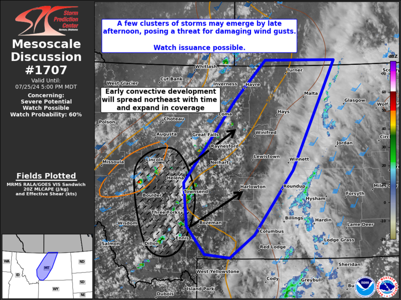
   Mesoscale Discussion 1707
   NWS Storm Prediction Center Norman OK
   0325 PM CDT Thu Jul 25 2024

   Areas affected...Southwestern into North-Central Montana

   Concerning...Severe potential...Watch possible

   Valid 252025Z - 252300Z

   Probability of Watch Issuance...60 percent

   SUMMARY...A few clusters of storms should emerge by late afternoon,
   posing a threat for damaging wind gusts. Watch issuance is possible.

   DISCUSSION...Visible satellite trends show persistent cumulus
   development in high terrain areas of southwestern into north-central
   Montana, with a few echoes now appearing on regional radar. This
   activity is developing in proximity to a cold front moving through
   the region, where surface heating and ample low-level moisture has
   allowed for destabilization coincident with upper-level forcing for
   ascent along the southern periphery of a mid-level trough. These
   factors are yielding MLCAPE values of 500-1000 J/kg. Strong flow
   associated with the trough is also yielding a broad region of
   deep-layer shear overspreading the area, with effective bulk shear
   values of 30-40 kt.

   The convective trends noted above are expected to continue. The
   early convection, mainly over southwest Montana presently, is
   expected to move northeast and expand in coverage, resulting in
   scattered thunderstorms within a southwest to northeast oriented
   corridor over central Montana by late afternoon/early evening. A few
   clusters of storms may emerge with time. Strong low-level lapse
   rates (> 9 C/km) across the region and the aforementioned enhanced
   flow aloft should allow for strong to severe outflow winds,
   particularly with any clusters of storms that develop. Given this
   potential, watch issuance is possible for the region and convective
   trends will be monitored.

   ..Karstens/Smith.. 07/25/2024

   ...Please see www.spc.noaa.gov for graphic product...

   ATTN...WFO...BYZ...GGW...TFX...

   LAT...LON   45490937 45021010 45091084 45671139 46561149 47451073
               48280998 49110903 49100691 46840821 45490937
|
|
|
Top/All Mesoscale Discussions/Forecast Products/Home |
|