|
|
| Mesoscale Discussion 1704 | |
| < Previous MD | |

|
|
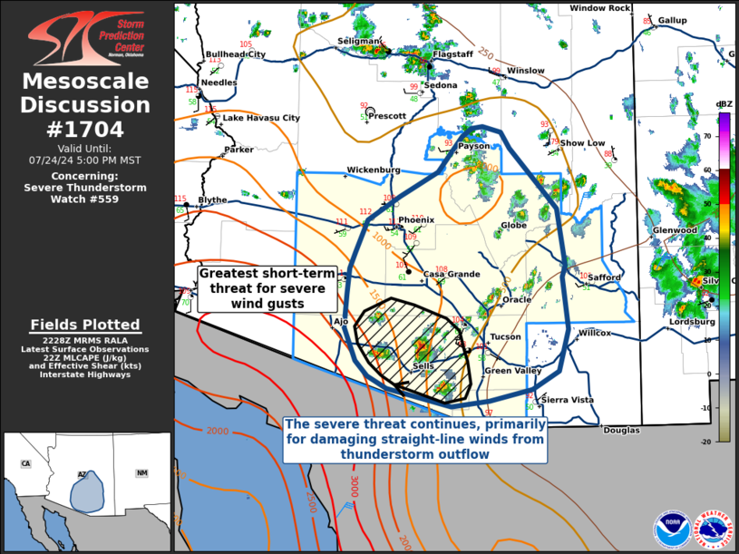
Mesoscale Discussion 1704 NWS Storm Prediction Center Norman OK 0531 PM CDT Wed Jul 24 2024 Areas affected...Southern Arizona Concerning...Severe Thunderstorm Watch 559... Valid 242231Z - 250000Z The severe weather threat for Severe Thunderstorm Watch 559 continues. SUMMARY...The severe threat continues across WW 559, primarily for severe wind gusts from thunderstorm outflow. DISCUSSION...The severe thunderstorm threat continues for WW 559 across southern Arizona, where daytime heating has resulted in surface temperatures rising into the 110s F. With surface dewpoints in the lower-to-mid 60s F, MLCAPE values of 1000-1500 J/kg across southwest portions of the watch area will continue to support thunderstorm development in the short term. Proximity sounding profiles show deeply mixed boundary layers with large saturation deficits, and very-weak to weak deep layer shear, supporting the threat for severe wind gusts from thunderstorm outflow. The greatest short-term threat for severe wind gusts is currently confined to southern portions of the watch, where buoyancy is maximized and thunderstorms are ongoing. This threat will continue as storms move southwest towards the Mexican border, but should diminish after dark. ..Halbert/Lyons.. 07/24/2024 ...Please see www.spc.noaa.gov for graphic product... ATTN...WFO...TWC...FGZ...PSR... LAT...LON 31611090 31551137 31651183 31741218 31871242 32031256 32371270 32721267 32991265 33161258 33511242 33761202 34021154 34381124 34481113 34501099 34431075 34261064 33851026 33621006 33020995 32911000 32350993 31921005 31731038 31611090 |
|
|
Top/All Mesoscale Discussions/Forecast Products/Home |
|