|
|
| Mesoscale Discussion 1690 | |
| < Previous MD | |

|
|
   Mesoscale Discussion 1690
   NWS Storm Prediction Center Norman OK
   0111 PM CDT Sun Jul 21 2024

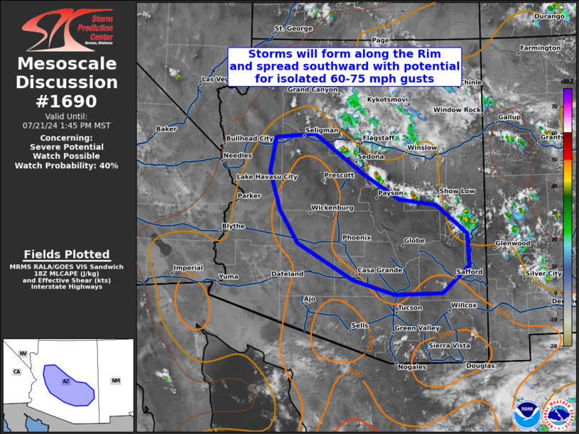
   Areas affected...Mogollon Rim of AZ and adjacent lower deserts

   Concerning...Severe potential...Watch possible

   Valid 211811Z - 212045Z

   Probability of Watch Issuance...40 percent

   SUMMARY...Thunderstorms will form over the Mogollon Rim through 20z
   and spread southward this afternoon with the potential to produce
   isolated outflow gusts of 60-75 mph.  The need for a watch is
   uncertain.

   DISCUSSION...Visible imagery depicts deepening cumulus over the
   Mogollon Rim in a zone of strong surface heating, immediately
   downstream from a subtle midlevel perturbation over northern AZ.
   Continued surface heating/destabilization will contribute to MLCAPE
   near 1000 J/kg with minimal convective inhibition, while modest
   (10-20 kt) northerly midlevel flow suggests that storms and
   resultant cold pools will spread southward off the Rim and toward
   the lower deserts this afternoon.  Typical inverted-V profiles with
   the moderate buoyancy will support precipitation-loaded downbursts
   capable of producing isolated outflow gusts of 60-75 mph as storms
   move off the higher terrain and some coalescence of storms/cold
   pools occurs.  Isolated instances of marginally severe hail may also
   occur with the initial storms near the Rim. Confidence in storm
   formation is high, but the number of storms that will be capable of
   producing damaging/severe outflow gusts is less certain.  Thus, the
   need for a severe thunderstorm watch is uncertain.

   ..Thompson/Smith.. 07/21/2024

   ...Please see www.spc.noaa.gov for graphic product...

   ATTN...WFO...TWC...FGZ...PSR...VEF...

   LAT...LON   32781183 33431297 34011335 34681357 35281346 35351263
               34641161 34191085 34101008 33580943 33020940 32540996
               32521096 32781183
|
|
|
Top/All Mesoscale Discussions/Forecast Products/Home |
|


