|
|
| Mesoscale Discussion 1660 | |
| < Previous MD Next MD > | |

|
|
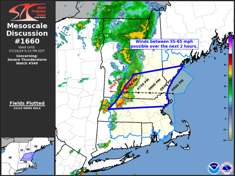
Mesoscale Discussion 1660 NWS Storm Prediction Center Norman OK 0614 PM CDT Tue Jul 16 2024 Areas affected...Southern New Hampshire and northern Massachusetts Concerning...Severe Thunderstorm Watch 549... Valid 162314Z - 170115Z The severe weather threat for Severe Thunderstorm Watch 549 continues. SUMMARY...The severe wind threat across WW 549 will mostly remain focused across southern New Hampshire and northern Massachusetts for the next 2 hours before a line of storms moves off shore. Wind gusts upwards of 55 to 65 mph appear possible based on environmental conditions and recent observations. DISCUSSION...A well-organized MCS continues to push east across the New England region with a recent wind report of 66 mph noted in Berkshire county, MA within the last hour. Temperatures are falling into the low to mid 70s in the wake of the line, indicating that a deep cold pool remains in place and should help maintain MCS intensity for the near-term with wind gusts up to 55-65 mph possible. This assertion is supported by recent velocity imagery from KENX, which shows at least two focused corridors of stronger winds within the line. Immediately downstream of the MCS, a plume of relatively higher theta-e is noted in recent surface observations/analyses as low 70s dewpoints continue to advect northward. This local corridor of better buoyancy should also help maintain MCS intensity as it translates eastward towards the New England coast. Latest timing estimates suggest the gust front should reach the coast roughly around 01 UTC, though the severe wind threat may persist after 01 UTC for far southern Maine. ..Moore.. 07/16/2024 ...Please see www.spc.noaa.gov for graphic product... ATTN...WFO...GYX...BOX...ALY... LAT...LON 42397311 42587285 42847261 43117239 43297219 43407212 43667015 43477033 43247058 42987076 42797080 42647073 42577074 42487086 42397311 |
|
|
Top/All Mesoscale Discussions/Forecast Products/Home |
|


