|
|
| Mesoscale Discussion 1650 | |
| < Previous MD | |

|
|
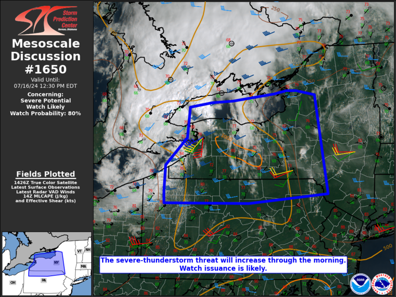
   Mesoscale Discussion 1650
   NWS Storm Prediction Center Norman OK
   0933 AM CDT Tue Jul 16 2024

   Areas affected...Western/central NY into northern PA

   Concerning...Severe potential...Watch likely

   Valid 161433Z - 161630Z

   Probability of Watch Issuance...80 percent

   SUMMARY...The severe-thunderstorm threat will increase through the
   morning, with a threat of damaging winds, isolated hail, and
   possibly a tornado. Watch issuance is likely.

   DISCUSSION...A well-defined MCV is moving across parts of southern
   Ontario this morning, with storms already increasing in coverage and
   intensity in the vicinity of Lake Ontario. Diurnal
   heating/destabilization downstream of the MCV will support more
   widespread thunderstorm development across western NY and perhaps
   northern PA later this morning. Rather substantial enhancement to
   low/midlevel flow related to the MCV (which is already noted on KPBZ
   and KBUF VWPs) will support organized convection, in the presence of
   MLCAPE increasing into the 1000-2000 J/kg range.

   While eventual clustering and potential MCS development is expected,
   a couple of supercells will also be possible, both with initial
   development, and also embedded in any upscale growth that occurs
   later in convective evolution. Scattered damaging wind and localized
   gusts of 60-70 mph will be possible by late morning into the
   afternoon, along with some potential for isolated hail and a tornado
   or two with any persistent supercells. Watch issuance is likely by
   late morning in order to address these threats.

   ..Dean/Hart.. 07/16/2024

   ...Please see www.spc.noaa.gov for graphic product...

   ATTN...WFO...ALY...BGM...BUF...CTP...PBZ...CLE...

   LAT...LON   41717988 42307985 42927920 43627914 43737845 43777781
               43937653 44007615 43997585 43897527 41647491 41457731
               41447987 41717988
|
|
|
Top/All Mesoscale Discussions/Forecast Products/Home |
|