| Mesoscale Discussion 165 | |
| < Previous MD | |
|
|
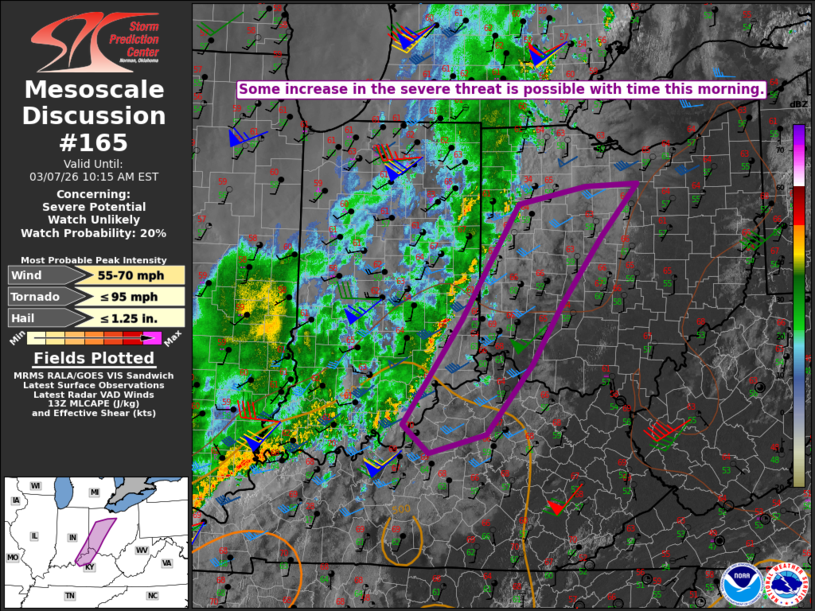
   Mesoscale Discussion 0165
   NWS Storm Prediction Center Norman OK
   0752 AM CST Sat Mar 07 2026

   Areas affected...Parts of southeast IN...northern
   KY...western/central OH

   Concerning...Severe potential...Watch unlikely

   Valid 071352Z - 071515Z

   Probability of Watch Issuance...20 percent

   SUMMARY...Some increase in the severe threat is possible with time
   this morning.

   DISCUSSION...A loosely organized QLCS is currently moving across
   eastern IN, downstream of a mid/upper-level shortwave trough moving
   across the Upper Midwest. Despite strong low-level flow, this QLCS
   has generally remained subsevere thus far this morning, due to weak
   buoyancy and only modest large-scale ascent. However, relatively
   steep midlevel lapse rates were noted on the 12Z ILN sounding, and
   some increase in buoyancy is expected with time as continued heating
   and moistening occurs within the already warm boundary layer.

   With relatively gradual improvement of the downstream environment
   expected in the short term, potential for locally damaging wind and
   perhaps a brief tornado may remain rather isolated through mid
   morning, rendering the need for short-term watch issuance uncertain.
   A more substantial increase in the severe threat remains possible
   from late morning into the afternoon, as ongoing convection moves
   into an environment where greater pre-storm heating and
   destabilization is expected.

   ..Dean/Gleason.. 03/07/2026

   ...Please see www.spc.noaa.gov for graphic product...

   ATTN...WFO...CLE...ILN...LMK...IWX...IND...

   LAT...LON   39668357 38968401 38158470 37948555 38268593 39468508
               40828421 41018321 41058242 40728273 40438298 39668357

   MOST PROBABLE PEAK TORNADO INTENSITY...UP TO 95 MPH
   MOST PROBABLE PEAK WIND GUST...55-70 MPH
   MOST PROBABLE PEAK HAIL SIZE...UP TO 1.25 IN
|
|
|
Top/All Mesoscale Discussions/Forecast Products/Home |
|
Source link