|
|
| Mesoscale Discussion 1646 | |
| < Previous MD | |

|
|
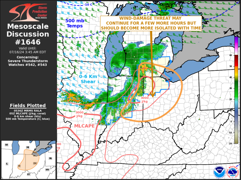
Mesoscale Discussion 1646 NWS Storm Prediction Center Norman OK 1238 AM CDT Tue Jul 16 2024 Areas affected...Eastern Indiana...Western and Central Ohio...Southeast Lower Michigan Concerning...Severe Thunderstorm Watch 542...543... Valid 160538Z - 160745Z The severe weather threat for Severe Thunderstorm Watch 542, 543 continues. SUMMARY...A wind-damage threat may continue for a few more hours across the southern Great Lakes region. The threat is expected to impact parts of western and central Ohio. However, the threat is expected to become more isolated with time. DISCUSSION...The latest mosaic radar imagery shows a decaying linear MCS from southern Lower Michigan into central Indiana and Central Illinois. The eastern most part of the MCS is located near a pocket of strong instability, where MLCAPE is estimated by the RAP in the 3000 to 3500 J/kg range. In addition to the instability, the convective line is being supported by a shortwave trough, evident on water vapor imagery over the southwestern Great Lakes. A distinct 50 to 70 knot rear inflow jet is analyzed by the RAP just behind the MCS. This feature will help the linear MCS to remain strong enough for an isolated wind-damage threat for a few more hours. However, satellite imagery shows warming cloud tops over the last hour, corresponding to more ragged reflectively on radar, suggesting that the MCS will continue to gradually decrease in intensity. ..Broyles.. 07/16/2024 ...Please see www.spc.noaa.gov for graphic product... ATTN...WFO...PBZ...CLE...ILN...DTX...IWX...GRR...IND... LAT...LON 39638643 39438639 39258609 39128494 39328362 39948253 40698197 41368184 41888220 42238297 42528453 42418507 41958514 41118520 40398572 39888622 39638643 |
|
|
Top/All Mesoscale Discussions/Forecast Products/Home |
|
Source link


