| Mesoscale Discussion 161 | |
| < Previous MD Next MD > | |

|
|
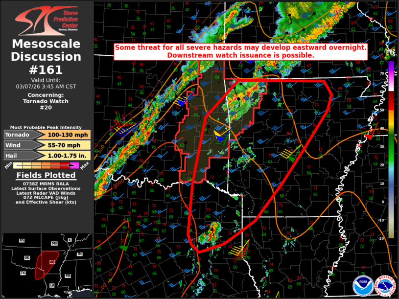
Mesoscale Discussion 0161 NWS Storm Prediction Center Norman OK 0140 AM CST Sat Mar 07 2026 Areas affected...Parts of eastern OK/northeast TX into central/western AR Concerning...Tornado Watch 20... Valid 070740Z - 070945Z The severe weather threat for Tornado Watch 20 continues. SUMMARY...Some threat for all severe hazards may develop eastward overnight. Downstream watch issuance is possible. DISCUSSION...Loosely organized convection is ongoing early this morning from eastern OK into northwest AR. While some weakening of low-level flow has been noted in the KSRX VWP, wind profiles remain quite favorable for organized storms, with moderate deep-layer shear and effective SRH near/above 250 m2/s2. SPC objective mesoanalysis and short-term RAP forecasts suggest maintenance or a modest increase in MLCAPE will be possible overnight, as somewhat richer low-level moisture continues to be transported into the region from the southwest. This could still lead to some intensification of ongoing convection prior to the arrival of an approaching cold front, with potential for localized severe hail/wind and possibly a tornado. Farther south, storms are gradually increasing in coverage and intensity across northeast TX, within the zone of somewhat richer/deeper low-level moisture. Given the time of night and relatively subtle forcing across the region, uncertainty remains regarding potential for this area of convection to mature, but supercell development will be possible as this area of convection spreads northeastward. Any sustained supercells within this environment could pose a threat for all severe hazards, so new watch issuance from northeast TX into much of AR is possible if trends support maturation of these prefrontal storms. ..Dean/Gleason.. 03/07/2026 ...Please see www.spc.noaa.gov for graphic product... ATTN...WFO...LZK...SHV...TSA...FWD... LAT...LON 32569565 33889554 35519517 36469417 36459311 36429150 36079126 35669142 34769212 33879283 32929365 32339457 32119531 32309553 32569565 MOST PROBABLE PEAK TORNADO INTENSITY...100-130 MPH MOST PROBABLE PEAK WIND GUST...55-70 MPH MOST PROBABLE PEAK HAIL SIZE...1.00-1.75 IN |
|
|
Top/All Mesoscale Discussions/Forecast Products/Home |
|
Source link