| Mesoscale Discussion 156 | |
| < Previous MD | |

|
|
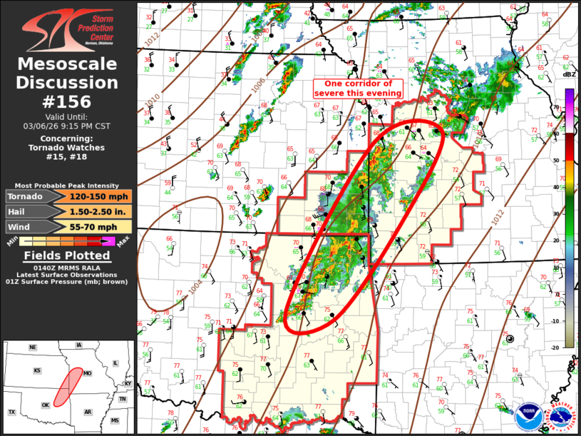
Mesoscale Discussion 0156 NWS Storm Prediction Center Norman OK 0743 PM CST Fri Mar 06 2026 Areas affected...Northeast Oklahoma to West-Central Missouri Concerning...Tornado Watch 15...18... Valid 070143Z - 070315Z The severe weather threat for Tornado Watch 15, 18 continues. SUMMARY...Supercell threat, with isolated tornadoes, continues this evening. DISCUSSION...Complex mode of convection has evolved from northeast OK into west-central MO. Strong low-level warm advection is noted along this corridor, coincident with the LLJ. VWP data from INX/SGF/EAX all exhibit 0-3 SRH values in excess of 400 m2/s2, and ample buoyancy was noted on the 00z soundings from SGF/TOP/OUN. OUN was particularly noteworthy with 2100 J/kg MLCAPE and negligible inhibition. Latest radar data depicts at least two long-lived supercells over northeast OK, embedded within a broader mixed-mode elongated convective band. This activity will continue to spread/develop northeast, along with an attendant risk for tornadoes and perhaps some large hail. ..Darrow.. 03/07/2026 ...Please see www.spc.noaa.gov for graphic product... ATTN...WFO...SGF...EAX...TSA...ICT... LAT...LON 35679631 38559447 38709303 37289384 35569533 35679631 MOST PROBABLE PEAK TORNADO INTENSITY...120-150 MPH MOST PROBABLE PEAK WIND GUST...55-70 MPH MOST PROBABLE PEAK HAIL SIZE...1.50-2.50 IN |
|
|
Top/All Mesoscale Discussions/Forecast Products/Home |
|
Source link