| Mesoscale Discussion 1559 | |
| < Previous MD | |

|
|
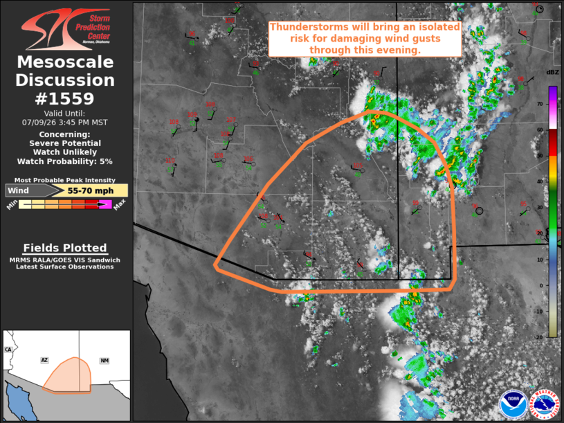
   Mesoscale Discussion 1559
   NWS Storm Prediction Center Norman OK
   0345 PM CDT Thu Jul 09 2026

   Areas affected...portions of southeastern Arizona into southwestern
   New Mexico

   Concerning...Severe potential...Watch unlikely

   Valid 092045Z - 092245Z

   Probability of Watch Issuance...5 percent

   SUMMARY...Thunderstorms developing along the White Mountains will
   progress southwestward through this evening with a threat for
   isolated damaging wind gusts.

   DISCUSSION...Latest visible satellite imagery depicts ongoing
   thunderstorm development across the White Mountains of southeastern
   Arizona and southwestern New Mexico amid a plume of enhanced
   mid-level moisture along the eastern periphery of upper-level
   ridging. Expectation is for these storms to gradually evolve
   south-southwestward off of the high terrain through this evening. As
   this evolution occurs, weak buoyancy (200-500 J/kg MLCAPE) based
   atop a deep, well-mixed boundary layer (LCLs of 3.0-3.5 km AGL) will
   support a risk for isolated damaging wind gusts. Weak effective
   shear (less than 20 kts) and deep-layer flow (less than 15-20 kts
   sampled by the EMX VWP) will largely limit storm organization and
   preclude a more widespread severe risk. Thus, watch issuance is not
   expected.

   ..Chalmers/Thompson.. 07/09/2026

   ...Please see www.spc.noaa.gov for graphic product...

   ATTN...WFO...ABQ...EPZ...TWC...FGZ...PSR...

   LAT...LON   31180890 31190823 31320813 32010813 32590816 32910825
               33230844 33430872 33590908 33650923 33660951 33500999
               33231056 32651117 31851179 31521201 31441197 31191111
               31151093 31180890

   MOST PROBABLE PEAK WIND GUST...55-70 MPH
|
|
|
Top/All Mesoscale Discussions/Forecast Products/Home |
|
Source link