| Mesoscale Discussion 1541 | |
| < Previous MD | |

|
|
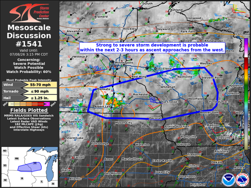
   Mesoscale Discussion 1541
   NWS Storm Prediction Center Norman OK
   0115 PM CDT Wed Jul 08 2026

   Areas affected...Southeast Minnesota into central Wisconsin

   Concerning...Severe potential...Watch possible

   Valid 081815Z - 082015Z

   Probability of Watch Issuance...60 percent

   SUMMARY...Isolated large hail and damaging winds are the primary
   concerns with widely scattered to scattered storms this afternoon. A
   watch is possible should convective trends warrant.

   DISCUSSION...Thunderstorms have initiated near a stationary boundary
   in southern Minnesota. This activity is tied to an upstream
   shortwave trough in western Minnesota per water vapor imagery.
   Filtered heating through cirrus clouds has allowed temperatures to
   rise into the low/mid 80s F. The very moist air will support around
   1500 J/kg MLCAPE. Continued heating and increasing mid-level ascent
   will eventually lead to widely scattered to scattered storms.
   Isolated damaging winds and hail may occur with the strongest
   storms, though low/mid-level lapse rates are not overly steep. The
   surface reflection of the shortwave trough is also rather nebulous.
   Even so, low-level shear is sufficient for weakly rotating storms
   conditionally capable of a brief tornado. A watch may be needed this
   afternoon.

   ..Wendt/Hart.. 07/08/2026

   ...Please see www.spc.noaa.gov for graphic product...

   ATTN...WFO...GRB...MKX...ARX...MPX...DMX...

   LAT...LON   43329122 43369242 43349357 43549433 44199412 44869066
               44888941 44618906 44128887 43748892 43608911 43548969
               43329122

   MOST PROBABLE PEAK TORNADO INTENSITY...UP TO 90 MPH
   MOST PROBABLE PEAK WIND GUST...55-70 MPH
   MOST PROBABLE PEAK HAIL SIZE...UP TO 1.25 IN
|
|
|
Top/All Mesoscale Discussions/Forecast Products/Home |
|
Source link