| Mesoscale Discussion 1530 | |
| < Previous MD | |

|
|
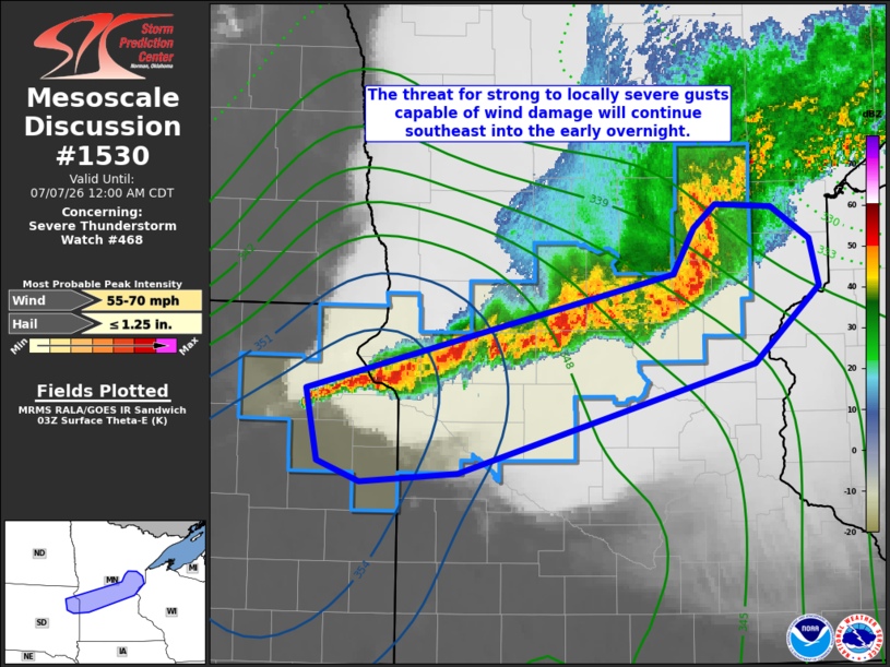
Mesoscale Discussion 1530 NWS Storm Prediction Center Norman OK 1034 PM CDT Mon Jul 06 2026 Areas affected...northeast SD...central MN Concerning...Severe Thunderstorm Watch 468... Valid 070334Z - 070500Z The severe weather threat for Severe Thunderstorm Watch 468 continues. SUMMARY...The threat for strong to locally severe gusts capable of wind damage will continue into the early overnight. Peak gusts 50-65 mph are possible with the stronger surges and inflections within the squall line. DISCUSSION...Radar mosaic shows a mature squall line extending from northeast SD east-northeastward across central MN late this evening. Despite gradual nocturnal cooling, the boundary layer remains supportive of stronger downdrafts penetrating through increased SBCINH. The deeper thunderstorm cores will preferentially favor the western 1/2 to 1/3 of the squall line where both the lead gust front and parent updrafts have not become substantially displaced, and in closer proximity to higher theta-e. As a result, the strong to locally severe wind threat will favor the western half of of the Watch over the next couple of hours but perhaps also extend farther east where small-scale bowing segments have matured. ..Smith.. 07/07/2026 ...Please see www.spc.noaa.gov for graphic product... ATTN...WFO...DLH...MPX...ABR... LAT...LON 45539301 44809587 44739682 44889723 45369733 46149379 46459359 46629339 46609284 46379248 46069239 45539301 MOST PROBABLE PEAK WIND GUST...55-70 MPH MOST PROBABLE PEAK HAIL SIZE...UP TO 1.25 IN |
|
|
Top/All Mesoscale Discussions/Forecast Products/Home |
|
Source link