| Mesoscale Discussion 1529 | |
| < Previous MD | |

|
|
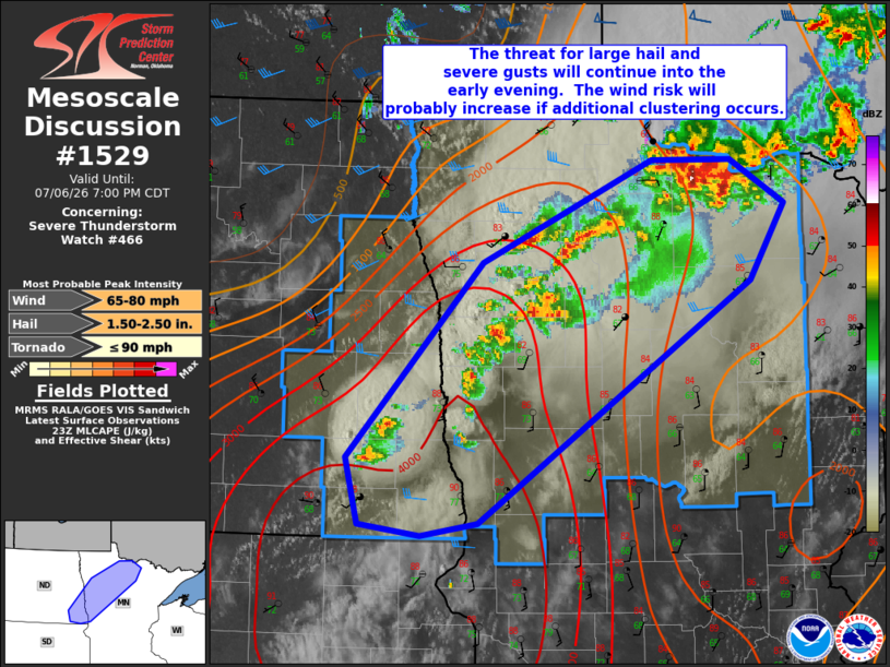
Mesoscale Discussion 1529 NWS Storm Prediction Center Norman OK 0602 PM CDT Mon Jul 06 2026 Areas affected...southeast ND...northwest into northern MN Concerning...Severe Thunderstorm Watch 466... Valid 062302Z - 070000Z The severe weather threat for Severe Thunderstorm Watch 466 continues. SUMMARY...The threat for large hail and severe gusts will continue into the early evening. The wind risk will probably increase if additional storm mergers occur and a severe cluster evolves over northern MN. DISCUSSION...Visible satellite/radar mosaic composite shows a few strong to severe storms ahead of a cold front from southeast ND into northern MN. Surface temperatures remain warm to the southeast of the ongoing storm activity with lower to mid 80s deg F, with dewpoints ranging from the 70s in southeast ND to the mid 60s in northern MN. The glancing of a Canadian mid-level shortwave trough and associated large-scale ascent will provide continued impetus for storm development and sustenance through the early to mid evening. Large hail will likely focus with the stronger cells located to the west and southwest of the northern MN clustering of storms, and also as storms mature over southeast ND into western MN this evening. MRMS MESH has mostly shown remotely-sensed hail diameter values 1 to 1.5 inches. However, larger hail in the 1.5 to 2 inches in diameter range will remain possible with a supercell. The severe-wind threat will probably begin to increase as further merging of outflow and storm clustering evolves during the evening. Given adequately steep 0-3 km lapse rates with relatively high PW, some of the more intense water-loaded cores may yield a risk for 60-75 mph gusts. ..Smith.. 07/06/2026 ...Please see www.spc.noaa.gov for graphic product... ATTN...WFO...DLH...FGF...ABR... LAT...LON 46509779 47879639 48599463 48599382 48299326 47749361 46049644 45959702 46029766 46509779 MOST PROBABLE PEAK TORNADO INTENSITY...UP TO 90 MPH MOST PROBABLE PEAK WIND GUST...65-80 MPH MOST PROBABLE PEAK HAIL SIZE...1.50-2.50 IN |
|
|
Top/All Mesoscale Discussions/Forecast Products/Home |
|
Source link