

| Mesoscale Discussion 1528 | |
| < Previous MD | |

|
|
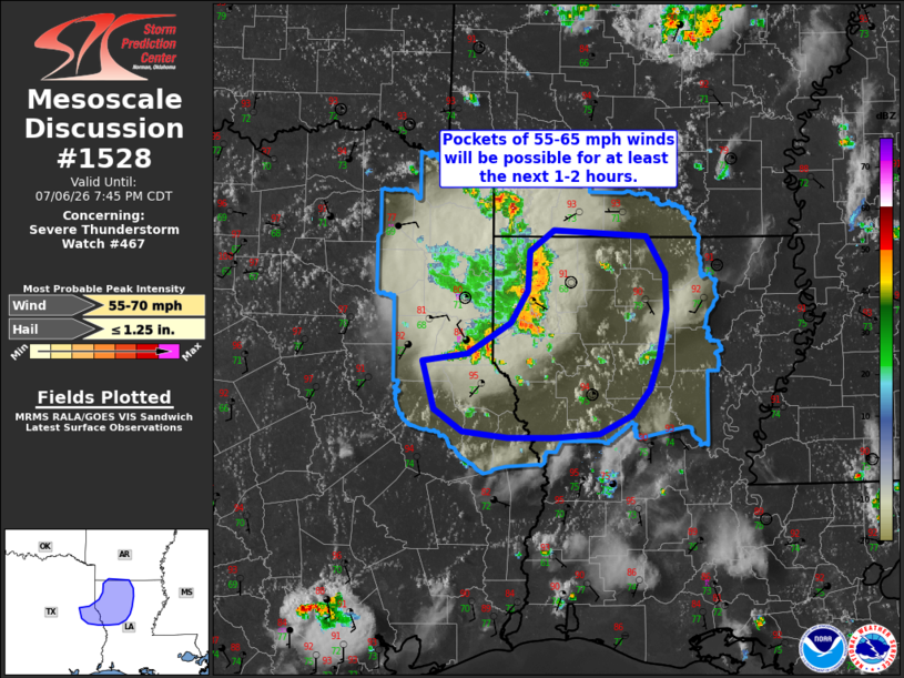
Mesoscale Discussion 1528 NWS Storm Prediction Center Norman OK 0538 PM CDT Mon Jul 06 2026 Areas affected...North-central Louisiana into far east Texas Concerning...Severe Thunderstorm Watch 467... Valid 062238Z - 070045Z The severe weather threat for Severe Thunderstorm Watch 467 continues. SUMMARY...A cluster of thunderstorms has been producing 50-65 mph winds over the past hour. Based on the downstream environment, similar wind speeds will be possible for the next couple of hours as the band of storms spreads east into north-central Louisiana. DISCUSSION...Radar imagery from KSHV shows swaths of strong low-level velocities within a cold-pool driven band of convection. KSHV and K4F2 (Carthage, TX) sampled 63 and 58 mph winds (respectively) with the passage of the band. Although deep-layer shear remains very limited in the vicinity of the band, fairly unstable conditions downstream (MLCAPE estimated to be around 2500 J/kg) will continue to promote strong updraft development along the leading edge of the outflow boundary. Somewhat steep low-level lapse rates of around 8 to 8.5 C/km will continue to facilitate downdraft accelerations and contribute to the development of additional swaths of strong to severe winds. Based on the downstream environment, peak wind gusts will most likely remain in the 50-70 mph range. A weak/shallow cold pool associated with diminishing convection across north-central LA may delineate the eastern edge of where these peak gusts may occur, but warmer temperatures to the southeast and better alignment of the cold pool with the deep-layer wind shear vector may promote severe gusts as far south as the southern fringe of WW 467. ..Moore.. 07/06/2026 ...Please see www.spc.noaa.gov for graphic product... ATTN...WFO...SHV... LAT...LON 32019470 32079428 32329386 32579370 32909369 33079345 33019257 32729240 32439239 32049246 31789254 31579271 31429302 31389346 31399390 31449433 31619459 32019470 MOST PROBABLE PEAK WIND GUST...55-70 MPH MOST PROBABLE PEAK HAIL SIZE...UP TO 1.25 IN |
|
|
Top/All Mesoscale Discussions/Forecast Products/Home |
|
Source link