| Mesoscale Discussion 1527 | |
| < Previous MD | |

|
|
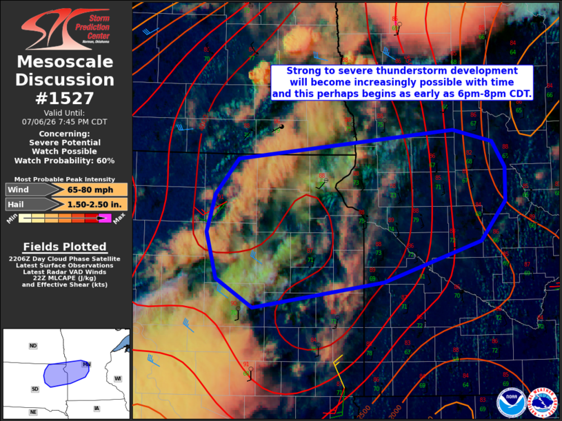
   Mesoscale Discussion 1527
   NWS Storm Prediction Center Norman OK
   0510 PM CDT Mon Jul 06 2026

   Areas affected...northeast SD...west-central into central MN

   Concerning...Severe potential...Watch possible

   Valid 062210Z - 070045Z

   Probability of Watch Issuance...60 percent

   SUMMARY...Strong to severe thunderstorm development will become
   increasingly possible with time and perhaps this begins as early as
   6pm-8pm CDT.  Isolated to scattered large hail and severe gusts are
   possible with the stronger storms through late evening.

   DISCUSSION...Visible-satellite imagery shows partly cloudy skies
   with a thin cirrus shield located to the southeast of an approaching
   front that is currently analyzed over southeast ND.  Surface
   observations over eastern SD and west-central MN show temperatures
   in the upper 80s with lower 70s deg F dewpoints.  The 20z model run
   of the RAP seems adequately representative of the surface conditions
   and it shows 4000 J/kg MLCAPE with PW in excess of 1.8 inches.
   Fairly weak southerly low-level flow veers to westerly and 20-kt in
   the 500-300 mb layer and this is supporting around 25-kt effective
   shear.  Short-term model guidance continues to suggest storms will
   eventually develop over the southern part of Severe Thunderstorm
   Watch #466 near the ND-SD-MN border region early this evening.
   Additional storms are possible over northeast SD into west-central
   MN this evening.  Contingent on storm development occurring, it
   seems plausible at least an isolated to perhaps scattered
   severe-storm risk will develop beginning this evening.  It remains
   unclear regarding storm evolution and the need for a severe
   thunderstorm watch due in part to storm coverage and propensity for
   severe hail/wind, but mesoscale conditions will continue to be
   monitored.

   ..Smith/Gleason.. 07/06/2026

   ...Please see www.spc.noaa.gov for graphic product...

   ATTN...WFO...MPX...FGF...FSD...ABR...

   LAT...LON   45149869 45539856 45889824 46179517 46059461 45809443
               45469442 45059477 44649616 44399803 44679854 45149869

   MOST PROBABLE PEAK WIND GUST...65-80 MPH
   MOST PROBABLE PEAK HAIL SIZE...1.50-2.50 IN
|
|
|
Top/All Mesoscale Discussions/Forecast Products/Home |
|
Source link