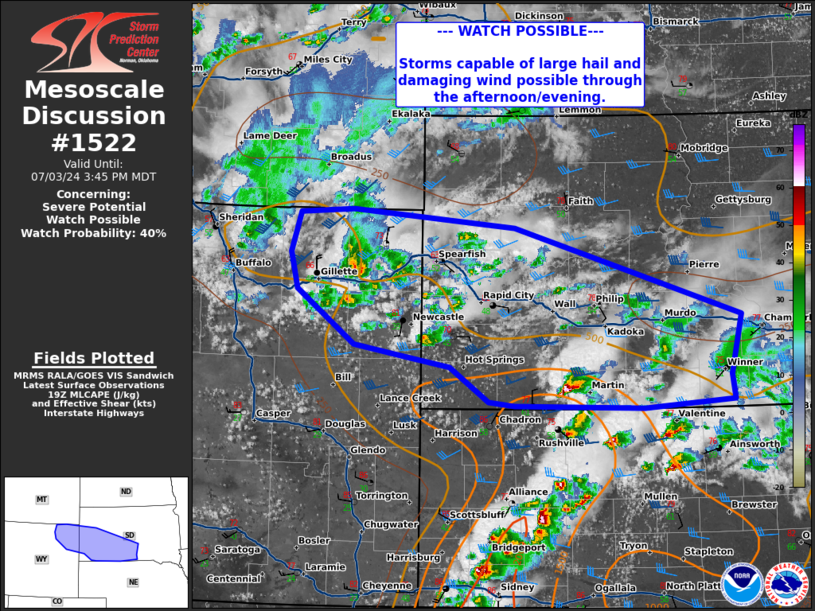
2024-07-03 16:45:03
1720040132
|
|
| Mesoscale Discussion 1522 | |
| < Previous MD | |

|
|
   Mesoscale Discussion 1522
   NWS Storm Prediction Center Norman OK
   0240 PM CDT Wed Jul 03 2024

   Areas affected...far eastern Wyoming into western South Dakota

   Concerning...Severe potential...Watch possible

   Valid 031940Z - 032145Z

   Probability of Watch Issuance...40 percent

   SUMMARY...Thunderstorm development will continue into the evening
   with potential for damaging wind and large hail.

   DISCUSSION...Thunderstorm activity has been ongoing across portions
   of eastern Wyoming into western South Dakota this afternoon. A
   recent 18z sounding from UNR shows meager instability with MLCAPE <
   250 J/kg and MUCAPE around 500 J/kg. Low-level moisture is also
   meager, with dew points generally in the mid 40s to 50s. Despite
   meager moisture, ample deep layer shear around 40-45 kts remains in
   place across eastern Wyoming into western South Dakota. Instability
   does increase near the Nebraska border south of the surface
   boundary. In this region, transient elevated supercells have been
   ongoing. Confidence in a sustained severe threat remains uncertain,
   given generally poor thermodynamics. This area will be monitored for
   trends and potential for watch issuance should additional storms
   intensify.

   ..Thornton/Gleason.. 07/03/2024

   ...Please see www.spc.noaa.gov for graphic product...

   ATTN...WFO...ABR...UNR...CYS...

   LAT...LON   43530431 43640498 44190578 44550589 44960575 44990502
               44820276 43929961 43329975 43079972 43000097 43030276
               43070311 43420366 43530431
|
|
|
Top/All Mesoscale Discussions/Forecast Products/Home |
|


