2024-07-03 14:47:05
1720033511
|
|
| Mesoscale Discussion 1521 | |
| < Previous MD | |

|
|
   Mesoscale Discussion 1521
   NWS Storm Prediction Center Norman OK
   0145 PM CDT Wed Jul 03 2024

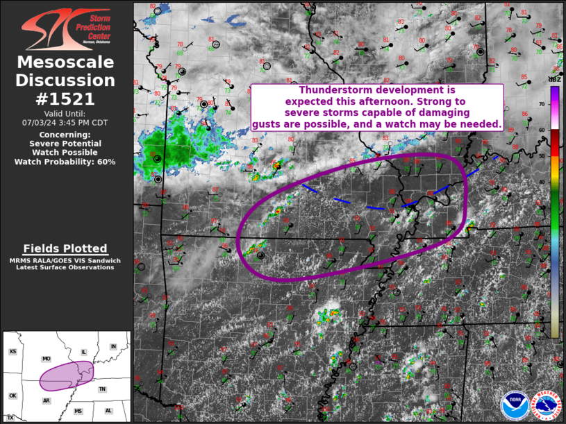
   Areas affected...South-Central/Southeast MO...Far Southern IL...Far
   Western KY...Far Northeast AR...Extreme Northwest TN

   Concerning...Severe potential...Watch possible

   Valid 031845Z - 032045Z

   Probability of Watch Issuance...60 percent

   SUMMARY...Thunderstorm development is expected this afternoon from
   the Ozark Plateau into the Lower OH Valley. Strong to severe storms
   capable of damaging gusts are possible, and convective trends will
   be monitored for potential watch issuance.

   DISCUSSION...Visible satellite imagery shows that the outflow
   associated with antecedent storms currently extends from about 40
   miles east-southeast of TBN (in south-central MO) eastward to the
   MO/KY border vicinity. Southward progress of this boundary has
   slowed significantly over the past hour, with current indications
   suggesting that the western portion of this boundary has stalled.
   Strong heating and low-level moisture advection will likely result
   in this boundary becoming increasingly diffuse with time, although
   there is some potential it returns northward as an effective warm
   front (particularly the western end).

   Cumulus continues to deepen south of the outflow boundary, where
   temperatures are now in the low 90s and dewpoints are in the low to
   mid 70s. These warm and moist conditions are fostering an uncapped
   environment with moderate to strong buoyancy. Recent mesoanalysis
   estimates MLCAPE is around 2000 to 3000 J/kg. Vertical shear is
   modest, with 0-6 km bulk shear currently around 25 to 30 kt. This
   may increase somewhat as slightly stronger mid-level flow attendant
   to a subtle convectively augmented vorticity maximum moves into the
   region.

   Current expectation is for thunderstorm coverage to increase this
   afternoon, supported by both ascent attendant to the convectively
   augmented vorticity maximum moving through the central Plains and
   low-level convergence. Strong buoyancy will support robust updrafts,
   but the lack of stronger shear will likely limit organization,
   promoting a predominantly multicellular mode. Even so, scattered
   coverage of these strong updrafts and resulting potential for
   damaging gusts may require the need for a watch.

   ..Mosier/Gleason.. 07/03/2024

   ...Please see www.spc.noaa.gov for graphic product...

   ATTN...WFO...PAH...MEG...LSX...LZK...SGF...

   LAT...LON   36269294 37139249 37819035 37888841 37138809 36408864
               35779189 36269294
|
|
|
Top/All Mesoscale Discussions/Forecast Products/Home |
|


