2024-07-03 14:47:05
1720032828
|
|
| Mesoscale Discussion 1520 | |
| < Previous MD Next MD > | |

|
|
   Mesoscale Discussion 1520
   NWS Storm Prediction Center Norman OK
   0102 PM CDT Wed Jul 03 2024

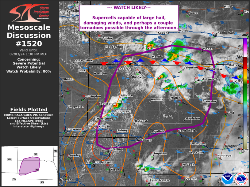
   Areas affected...Nebraska Panhandle into northwest/north-central
   Nebraska...southern South Dakota...and far northeast Colorado

   Concerning...Severe potential...Watch likely

   Valid 031802Z - 031930Z

   Probability of Watch Issuance...80 percent

   SUMMARY...Supercells capable of damaging winds, large hail, and
   tornadoes likely to develop through the afternoon.

   DISCUSSION...Visible satellite shows an increase in cu development
   across the southwestern Nebraska Panhandle over the last hour. The
   environment across northeastern Colorado into the Nebraska Panhandle
   is characterized by temperatures in the upper 70s to 80s with dew
   points in the mid 50s to low 60s. Mesoanalysis indicates MLCAPE
   around 1000-1500 J/kg extending from northeastern Colorado into the
   Nebraska Panhandle along and east of a surface trough. Deep layer
   shear around 35-40 kts increases near a boundary located across
   northern Nebraska. CAM guidance has shown a signal for development
   of multiple supercells across the southwestern Nebraska Panhandle
   around 18-20z, with a few cells now on radar farther north near the
   NE/SD border, tracking into the slightly better moisture to the
   north and east. Initially, the main threats will likely be damaging
   winds and large hail given sufficient shear and steep mid-level
   lapse rates. As cells mature, potential for a tornado or two will be
   possible. A watch will likely be needed to cover this potential this
   afternoon.

   ..Thornton/Gleason.. 07/03/2024

   ...Please see www.spc.noaa.gov for graphic product...

   ATTN...WFO...FSD...LBF...UNR...BOU...CYS...

   LAT...LON   41220092 41120146 40750252 40690336 40800367 41150370
               42590320 43220276 43360193 43540095 43409968 43349951
               42909937 42409948 41869955 41389984 41300017 41220092
|
|
|
Top/All Mesoscale Discussions/Forecast Products/Home |
|


