2024-07-03 12:48:03
1720026095
|
|
| Mesoscale Discussion 1519 | |
| < Previous MD | |

|
|
   Mesoscale Discussion 1519
   NWS Storm Prediction Center Norman OK
   1146 AM CDT Wed Jul 03 2024

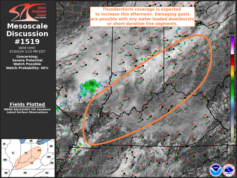
   Areas affected...Far Southeast IL...Northern/Western KY...Southern
   IN...Southwest/Central OH

   Concerning...Severe potential...Watch possible

   Valid 031646Z - 031915Z

   Probability of Watch Issuance...40 percent

   SUMMARY...Thunderstorms coverage is expected to increase across the
   OH Valley this afternoon. Damaging gusts are possible with any
   water-loaded downbursts or short-duration bowing segments, but the
   disorganized convective mode could limit the need for a watch.

   DISCUSSION...Surface temperatures have already climbed into the mid
   80s within a fairly narrow corridor ahead of the approaching cold
   front but west of the influence of the East Coast ridging (roughly
   from southeast IL northeastward along the OH River vicinity into
   western OH). Dewpoints are in the low 70s within this corridor, and
   the resulting warm and moist conditions are promoting quick airmass
   destabilization despite generally pool mid-level lapse rates. This
   destabilization is evidenced by cumulus development throughout much
   of the region. Relatively warm temperatures aloft and poor lapse
   rates combined with boundary-layer mixing will likely temper the
   overall instability, with MLCAPE expected to remain around 1000 J/kg
   areawide. Given that the stronger mid-level flow is displaced north
   of the region, vertical shear will be modest as well, with 0-6 km
   bulk shear around 25 to 30 kt.

   General expectation is for thunderstorm coverage to increase this
   afternoon within this corridor ahead of the front, with a
   multicellular mode dominating. Primary severe risk is forecast to be
   damaging gusts attendant to wet downbursts. There is some chance for
   bowing segments in areas where storm development occurs in close
   proximity and cold pools are able to amalgamate. Damaging gusts
   would be possible with these forward propagating segments as well.
   Convective trends will be monitored, but with a disorganized
   multicellular mode anticipated, a watch is not likely.

   ..Mosier/Gleason.. 07/03/2024

   ...Please see www.spc.noaa.gov for graphic product...

   ATTN...WFO...CLE...JKL...ILN...LMK...IWX...IND...PAH...ILX...

   LAT...LON   39018760 40918367 40658237 39138283 37548541 36648847
               37968877 39018760
|
|
|
Top/All Mesoscale Discussions/Forecast Products/Home |
|


