2024-07-02 19:30:06
1719963482
|
|
| Mesoscale Discussion 1516 | |
| < Previous MD | |

|
|
   Mesoscale Discussion 1516
   NWS Storm Prediction Center Norman OK
   0627 PM CDT Tue Jul 02 2024

   Areas affected...portions of far southern Wisconsin into northern
   and central Illinois

   Concerning...Severe potential...Watch possible

   Valid 022327Z - 030130Z

   Probability of Watch Issuance...40 percent

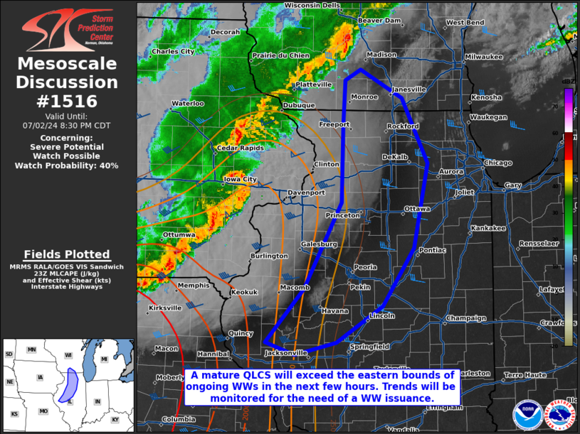
   SUMMARY...A QLCS is moving eastward across eastern IA and is
   approaching the MS River. Though buoyancy and shear decreases
   rapidly with eastern extent, the approaching QLCS may persist with a
   risk of isolated 50-60 mph wind gusts. Convective trends will be
   monitored for the need of a WW issuance.

   DISCUSSION...The ongoing QLCS, including a pronounced line-end
   mesovortex accompanied by a rear-inflow jet, continues to track
   eastward across eastern IA with a history of 60-80 mph wind gusts
   and reported tornadoes. The QLCS mesovortex is preceded by strong
   low-level shear, characterized by 300+ m2/s2 effective SRH (per 23Z
   mesoanalysis and the latest DVN VAD profiler data). As such, the
   QLCS may remain organized as it crosses the MS river in a few hours.
   However, buoyancy decreases/MLCINH increases substantially with
   eastward extent, which could weaken the MCS substantially by the
   time it enters IL. As such, continued severe potential east of the
   current bounds of WWs 497-498 is a bit uncertain. As such,
   convective trends will continue to be monitored for continued severe
   gust potential and subsequent need for a WW issuance as the QLCS
   begins to exit the ongoing watches.

   ..Squitieri/Smith.. 07/02/2024

   ...Please see www.spc.noaa.gov for graphic product...

   ATTN...WFO...LOT...ILX...MKX...LSX...DVN...

   LAT...LON   39909085 40509029 41478974 42348972 42848969 42968946
               42648884 41908847 40968868 40308914 39908981 39759042
               39909085
|
|
|
Top/All Mesoscale Discussions/Forecast Products/Home |
|


