| Mesoscale Discussion 151 | |
| < Previous MD Next MD > | |

|
|
Mesoscale Discussion 0151
NWS Storm Prediction Center Norman OK
0436 PM CST Fri Mar 06 2026
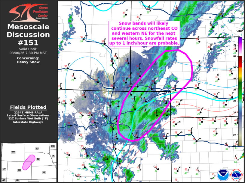
Areas affected...Northeast Colorado into western Nebraska
Concerning...Heavy snow
Valid 062236Z - 070230Z
SUMMARY...Moderate to heavy snow bands will likely continue into the
early evening hours across northeast Colorado into parts of western
Nebraska. Snowfall rates may exceed 1 inch/hour under the more
persistent bands.
DISCUSSION...Transient snow bands have been evident in regional
radar mosaics over the past couple of hours across northeast CO and
western NE. ASOS/AWOS observations under these bands have been
reporting visibility reductions down to 1/4 mile at times under the
heavier bands. Despite winds of 20-25 mph, blowing snow model output
suggests these visibility reductions are mainly attributable to
heavy snowfall rates given temperatures in the upper 20s/low 30s.
Heading into the evening hours, strong synoptic ascent within the
left-exit region of a passing upper jet coupled with more focused
frontogenetical lift between 850-700 mb will support a continuation
of at least transient heavy snow bands across northeast CO and into
parts of western NE for the next several hours. Although some areas
remain above freezing, an influx of colder air behind a passing cold
front should allow for temperatures through the lowest couple of
kilometers to fall below freezing and support moderate to heavy
snowfall rates later this evening. Based on recent observations and
latest model guidance, snowfall rates up to one inch/hour appear
likely under the heavier, more persistent snow bands.
..Moore.. 03/06/2026
...Please see www.spc.noaa.gov for graphic product...
ATTN...WFO...LBF...GLD...BOU...CYS...
LAT...LON 42530228 42560160 42410125 42110098 41800093 41460099
41230127 40930167 40650203 40030254 39520307 39180360
39130393 39220427 39430456 39770464 40110455 40630436
41130395 42210277 42530228
|
|
|
Top/All Mesoscale Discussions/Forecast Products/Home |
|
Source link