| Mesoscale Discussion 1507 | |
| < Previous MD | |

|
|
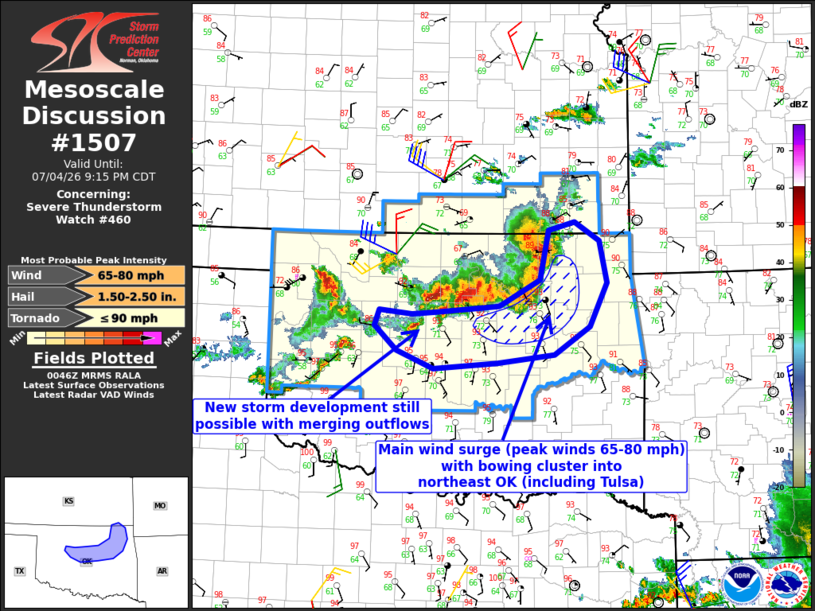
Mesoscale Discussion 1507 NWS Storm Prediction Center Norman OK 0748 PM CDT Sat Jul 04 2026 Areas affected...Northeast and central Oklahoma Concerning...Severe Thunderstorm Watch 460... Valid 050048Z - 050215Z The severe weather threat for Severe Thunderstorm Watch 460 continues. SUMMARY...The main wind surge through about 02z will continue into northeast Oklahoma, including the Tulsa area. Additional strong-severe storm development remains possible farther west, to the immediate north of the OKC metro area. DISCUSSION...The earlier storms along the KS/OK border have evolved into a bowing cluster with measured gusts of 61-66 mph via the OK mesonet. Though outflow is a bit ahead of the primary reflectivity/updrafts, the storms are well organized and should remain so across northeast OK in a strongly unstable environment with substantial deep-layer northwesterly shear. Farther west, there is still the potential for new storm development north of the OKC metro where outflow interactions are occurring. The environment is less moist compared to northeast OK, but ascent atop the outflows in a steep lapse rate environment could still support new updraft development and a subsequent threat for severe outflow gusts through at least 02z. ..Thompson.. 07/05/2026 ...Please see www.spc.noaa.gov for graphic product... ATTN...WFO...TSA...ICT...OUN... LAT...LON 35439660 35369756 35579811 35889843 36069836 36029788 36049745 36129657 36449597 37049584 37149544 36909507 36399497 35879522 35529576 35439660 MOST PROBABLE PEAK TORNADO INTENSITY...UP TO 90 MPH MOST PROBABLE PEAK WIND GUST...65-80 MPH MOST PROBABLE PEAK HAIL SIZE...1.50-2.50 IN |
|
|
Top/All Mesoscale Discussions/Forecast Products/Home |
|
Source link