| Mesoscale Discussion 1501 | |
| < Previous MD | |

|
|
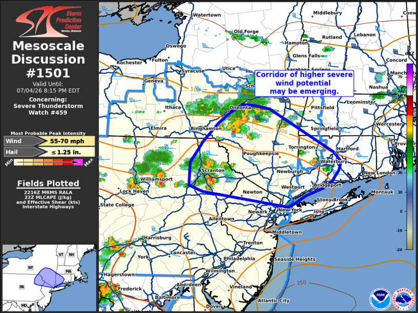
Mesoscale Discussion 1501 NWS Storm Prediction Center Norman OK 0518 PM CDT Sat Jul 04 2026 Areas affected...Northeast Pennsylvania into southern New York and western Connecticut Concerning...Severe Thunderstorm Watch 459... Valid 042218Z - 050015Z The severe weather threat for Severe Thunderstorm Watch 459 continues. SUMMARY...A corridor of higher severe wind potential may be emerging across parts of northeast Pennsylvania into southern New York over the next few hours. DISCUSSION...Latest GOES IR imagery shows steady cloud top cooling of convection near Scranton, PA and west of Albany, NY, hinting at gradual intensification. Regional VWPs from central/southern NY continue to show 30-40 knot mid-level flow over the region, which is supporting similar effective bulk shear values. This kinematic environment is favorable for maintenance of the ongoing convection and may promote further organization. Although regional buoyancy is not overly robust, a corridor of 1000-1500 J/kg MLCAPE remains in place immediately downstream of these clusters where low-level lapse rates remain near 8 C/km after full diurnal heating. These thermodynamic conditions will also promote storm maintenance and facilitate cold pool development. Given the downstream thermodynamic/kinematic environment, some uptick in severe wind potential appears likely over the next couple of hours with either of these clusters. ..Moore.. 07/04/2026 ...Please see www.spc.noaa.gov for graphic product... ATTN...WFO...BOX...OKX...ALY...PHI...BGM... LAT...LON 40867371 41127560 41227591 41597589 41947561 42257528 42437499 42557474 42547449 42487413 41767272 41617256 41467262 41277278 41177295 41047334 40867371 MOST PROBABLE PEAK WIND GUST...55-70 MPH MOST PROBABLE PEAK HAIL SIZE...UP TO 1.25 IN |
|
|
Top/All Mesoscale Discussions/Forecast Products/Home |
|
Source link