| Mesoscale Discussion 150 | |
| < Previous MD | |

|
|
Mesoscale Discussion 0150
NWS Storm Prediction Center Norman OK
0347 PM CST Fri Mar 06 2026
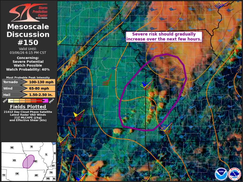
Areas affected...southeastern Kansas into western/central Missouri
Concerning...Severe potential...Watch possible
Valid 062147Z - 070015Z
Probability of Watch Issuance...40 percent
SUMMARY...The severe risk should gradually increase over the next
few hours. While timing is uncertain, a watch may eventually be
needed.
DISCUSSION...Slightly elevated convection is gradually deepening
within a zone of low-level warm advection over southwestern MO and
southeastern KS -- along the southeastern periphery of earlier
thunderstorm clusters. Here, boundary-layer dewpoints are increasing
into the lower 60s amid pockets of diurnal heating in cloud breaks.
While a low-level warm layer and related inhibition (evident in
earlier nearby soundings and forecast profiles) limits confidence in
thunderstorm evolution/maturation -- especially given weak
large-scale forcing for ascent -- the continued destabilization may
favor gradual intensification through the afternoon into this
evening. If thunderstorms can become surface-based, around 40-50 kt
of effective shear and large clockwise-curved low-level hodographs
would support supercells and organized clusters capable of damaging
winds, large hail, and a couple tornadoes.
Given the uncertainty on timing/evolution of the severe risk in this
corridor, a watch is not expected in the near-term, though
convective trends are being monitored.
..Weinman/Guyer.. 03/06/2026
...Please see www.spc.noaa.gov for graphic product...
ATTN...WFO...LSX...SGF...EAX...TSA...TOP...ICT...
LAT...LON 37929582 38539555 39269474 39649414 39739362 39609309
39309281 38809271 38019311 37219385 36939426 36929468
37069564 37479583 37929582
MOST PROBABLE PEAK TORNADO INTENSITY...100-130 MPH
MOST PROBABLE PEAK WIND GUST...65-80 MPH
MOST PROBABLE PEAK HAIL SIZE...1.50-2.50 IN
|
|
|
Top/All Mesoscale Discussions/Forecast Products/Home |
|
Source link