2024-06-30 18:45:05
1719788117
|
|
| Mesoscale Discussion 1499 | |
| < Previous MD | |

|
|
   Mesoscale Discussion 1499
   NWS Storm Prediction Center Norman OK
   0524 PM CDT Sun Jun 30 2024

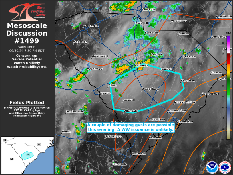
   Areas affected...portions of central into southern South Carolina

   Concerning...Severe potential...Watch unlikely

   Valid 302224Z - 302330Z

   Probability of Watch Issuance...5 percent

   SUMMARY...A couple of strong/damaging gusts (45-55 mph) may occur in
   wet downbursts with the stronger storms. A 60+ mph gust cannot be
   ruled out, but the severe threat should be too isolated to warrant a
   Severe Thunderstorm Watch issuance.

   DISCUSSION...Cold pool mergers are occurring with congealing
   multicellular storms over central SC, and these storms are
   progressing southward amid a highly buoyant airmass. Over 2500 J/kg
   MLCAPE precedes the storms, which should foster continued
   propagation of strong updrafts on the leading edge of the southern
   moving cold pool. Wet downbursts may accompany the stronger storm
   cores, with damaging gusts possible. Nonetheless, vertical wind
   shear is weak, so the overall severe threat should be sparse,
   precluding a Severe Thunderstorm Watch issuance.

   ..Squitieri.. 06/30/2024

   ...Please see www.spc.noaa.gov for graphic product...

   ATTN...WFO...ILM...CHS...CAE...

   LAT...LON   33668166 34078079 33847982 33537973 33318002 33138060
               33018108 33098155 33668166
|
|
|
Top/All Mesoscale Discussions/Forecast Products/Home |
|


