| Mesoscale Discussion 1491 | |
| < Previous MD | |

|
|
Mesoscale Discussion 1491
NWS Storm Prediction Center Norman OK
1149 AM CDT Sat Jul 04 2026
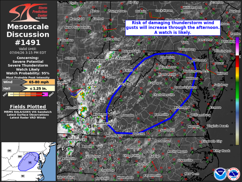
Areas affected...Much of Virginia...Maryland...and eastern West
Virginia,
Concerning...Severe potential...Severe Thunderstorm Watch likely
Valid 041649Z - 041915Z
Probability of Watch Issuance...95 percent
SUMMARY...Thunderstorms will increase in coverage and intensity
while developing eastward through the afternoon. The primary concern
will be scattered to numerous damaging wind gusts. A Severe
Thunderstorm Watch is likely.
DISCUSSION...Widely scattered thunderstorms are evolving along the
high terrain in WV and southwestern VA this afternoon. Continued
diurnal heating and orographic lift will favor increasing
thunderstorm development over the next few hours. Downstream, strong
diurnal heating/destabilization of a moist air mass (upper 60s to
lower 70s dewpoints) beneath steep midlevel lapse rates (sampled by
12Z soundings) will support thunderstorm intensification through the
afternoon. While fairly weak deep-layer shear may limit overall
thunderstorm organization, the aforementioned environment will favor
a mix of cells and loosely organized clusters capable of producing
scattered to numerous damaging wind gusts across much of VA and
eventually into MD. A Severe Thunderstorm Watch is likely for this
activity.
..Weinman/Hart.. 07/04/2026
...Please see www.spc.noaa.gov for graphic product...
ATTN...WFO...AKQ...LWX...RNK...PBZ...RLX...
LAT...LON 37548059 38018032 39057934 39427883 39597832 39647744
39547686 39357649 38907637 38057671 37237763 36667909
36688013 37028055 37548059
MOST PROBABLE PEAK WIND GUST...65-80 MPH
MOST PROBABLE PEAK HAIL SIZE...UP TO 1.25 IN
|
|
|
Top/All Mesoscale Discussions/Forecast Products/Home |
|
Source link