| Mesoscale Discussion 1486 | |
| < Previous MD | |

|
|
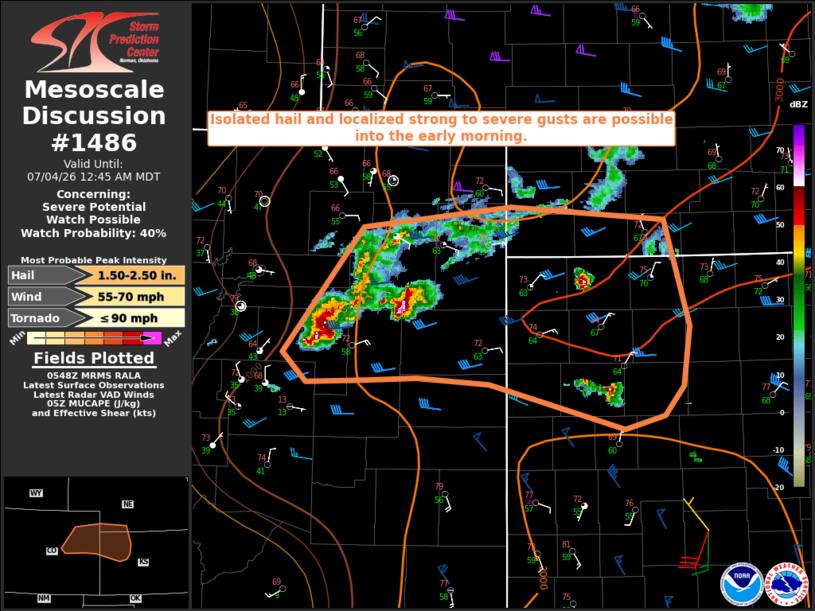
   Mesoscale Discussion 1486
   NWS Storm Prediction Center Norman OK
   1250 AM CDT Sat Jul 04 2026

   Areas affected...Parts of northeast CO into northwest KS and far
   southwest NE

   Concerning...Severe potential...Watch possible

   Valid 040550Z - 040645Z

   Probability of Watch Issuance...40 percent

   SUMMARY...Isolated hail and localized strong to severe gusts will be
   possible into the early morning.

   DISCUSSION...Storms have increased in coverage and intensity late
   tonight across parts of northeast CO, likely aided by warm advection
   in the 800-700 mb layer, to the north of a front draped from
   east-central CO into northwest KS. Moist low-level easterly flow
   beneath steep midlevel lapse rates is resulting in MUCAPE of
   near/above 1500 J/kg, with effective bulk shear likely around 30-40
   kt for convection rooted around 800 mb. This environment is
   supportive of at least transient storm organization, though rather
   weak upper-level flow will likely result in a complex storm mode.
   This could temper the longevity of the hail threat with any
   particular storm, though the environment otherwise supports hail
   approaching 2 inches in diameter. Localized severe gusts will also
   be possible in association with the strongest downdrafts and any
   larger-scale outflows.

   ..Dean/Mosier.. 07/04/2026

   ...Please see www.spc.noaa.gov for graphic product...

   ATTN...WFO...LBF...DDC...GLD...PUB...BOU...

   LAT...LON   39200440 40230355 40410199 40290038 39430011 38940018
               38690038 38590081 38960223 39000298 38990351 38960415
               39200440

   MOST PROBABLE PEAK TORNADO INTENSITY...UP TO 90 MPH
   MOST PROBABLE PEAK WIND GUST...55-70 MPH
   MOST PROBABLE PEAK HAIL SIZE...1.50-2.50 IN
|
|
|
Top/All Mesoscale Discussions/Forecast Products/Home |
|
Source link