| Mesoscale Discussion 1485 | |
| < Previous MD | |

|
|
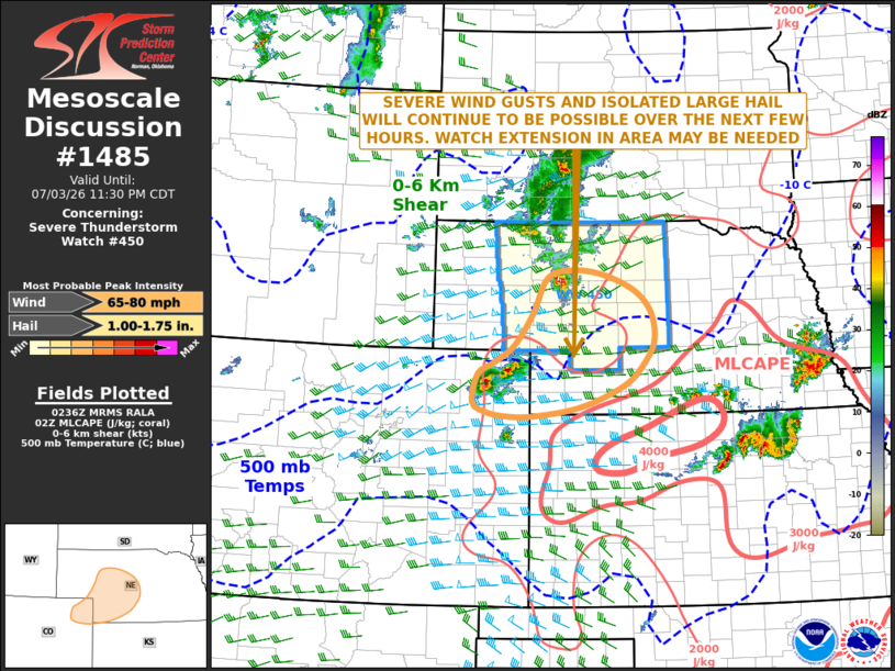
Mesoscale Discussion 1485 NWS Storm Prediction Center Norman OK 0937 PM CDT Fri Jul 03 2026 Areas affected...Central and Southwest Nebraska...Far Northeast Colorado Concerning...Severe Thunderstorm Watch 450... Valid 040237Z - 040430Z The severe weather threat for Severe Thunderstorm Watch 450 continues. SUMMARY...A threat for severe wind gusts and isolated large hail will likely continue over the next few hours. As storms move eastward into southwest Nebraska, a watch extension in area may be needed. DISCUSSION...The latest radar imagery shows a couple of intense storms over the central High Plains. The first storm is in west-central Nebraska with the second in far northeast Colorado. These storms are located near a shortwave trough evident on water vapor imagery, which is providing large-scale ascent helping to sustain the storms. Ahead of the storms, a moderately unstable airmass is located across much of southern and central Nebraska, where the RAP has MLCAPE in the 2000 to 3500 J/kg range. In addition, the North Platte WSR-88D VWP has 0-6 km shear around 40 knots. This will support supercell maintenance late this evening. Supercells should be capable of isolated large hail and severe wind gusts. As the storms in far northeast Colorado move eastward into southwest Nebraska later this evening, a watch extension in area may need to be considered. ..Broyles.. 07/04/2026 ...Please see www.spc.noaa.gov for graphic product... ATTN...WFO...GID...LBF...GLD...BOU... LAT...LON 41939990 42170055 42240119 42110170 41550200 41050240 40760285 40620311 40180322 40030297 39960257 39960198 40120098 40460007 40859965 41169949 41589956 41939990 MOST PROBABLE PEAK WIND GUST...65-80 MPH MOST PROBABLE PEAK HAIL SIZE...1.00-1.75 IN |
|
|
Top/All Mesoscale Discussions/Forecast Products/Home |
|
Source link