| Mesoscale Discussion 1483 | |
| < Previous MD Next MD > | |

|
|
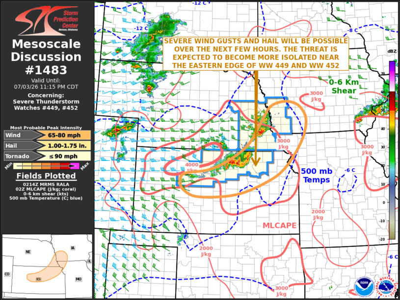
Mesoscale Discussion 1483 NWS Storm Prediction Center Norman OK 0916 PM CDT Fri Jul 03 2026 Areas affected...North-central and Northeast Kansas...Far Southeast Nebraska...Southwest Iowa...Far Northwest Missouri Concerning...Severe Thunderstorm Watch 449...452... Valid 040216Z - 040415Z The severe weather threat for Severe Thunderstorm Watch 449, 452 continues. SUMMARY...Severe wind gusts and isolated large hail will continue to be possible over the next few hours from parts of north-central Kansas northeastward into southwest Iowa. A watch extension in area may be needed to the south and east of the current watches. DISCUSSION...A broken line of strong to severe thunderstorms is ongoing near an axis of strong instability, where surface dewpoints range from the upper 60s to the mid 70s F. Across this moist airmass, the RAP shows an axis of instability with MLCAPE in the 3500 to 4500 J/kg range. The instability along with large-scale ascent associated with a mid-level shortwave trough is helping to maintain storm intensity within the line. The line will move slowly southeastward into northeast Kansas, far northwest Missouri and southwest Iowa over the next few hours. Although a severe threat is expected to continue through late this evening, the threat could become a bit more isolated as inhibition gradually increases. ..Broyles.. 07/04/2026 ...Please see www.spc.noaa.gov for graphic product... ATTN...WFO...DMX...EAX...OAX...TOP...ICT...GID...DDC...GLD... LAT...LON 41689486 41709538 41519589 41059625 40189689 39589786 39279875 39139980 38869998 38549984 38309911 38419739 38949587 39469508 40339441 41059420 41509445 41689486 MOST PROBABLE PEAK TORNADO INTENSITY...UP TO 90 MPH MOST PROBABLE PEAK WIND GUST...65-80 MPH MOST PROBABLE PEAK HAIL SIZE...1.00-1.75 IN |
|
|
Top/All Mesoscale Discussions/Forecast Products/Home |
|
Source link