| Mesoscale Discussion 1481 | |
| < Previous MD | |

|
|
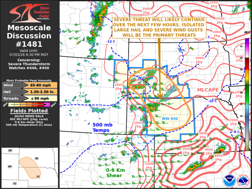
Mesoscale Discussion 1481 NWS Storm Prediction Center Norman OK 0727 PM CDT Fri Jul 03 2026 Areas affected...Southwestern South Dakota...Northwestern and North-central Nebraska Concerning...Severe Thunderstorm Watch 446...450... Valid 040027Z - 040230Z The severe weather threat for Severe Thunderstorm Watch 446, 450 continues. SUMMARY...A threat for severe wind gusts and isolated large hail will likely continue over the next few hours across parts of southwestern South Dakota into northwest and north-central Nebraska. DISCUSSION...On surface analysis, an axis of low-level convergence is located from western Nebraska northward into southwestern South Dakota, along which surface dewpoints are in the mid 50s to lower 60s F. Scattered strong to severe thunderstorms are ongoing near this axis of convergence, along which the RAP has a corridor of MLCAPE in the 2000 to 2500 J/kg range. In addition, the North Platte and Rapid City WSR-88D VWPs have 0-6 km shear in the 45 to 50 knot range. This environment will support a severe threat this evening. Supercells will be capable of isolated large hail and severe wind gusts. Short intense line segments will also be capable of strong to severe gusts. The threat will eventually move southeastward into north-central Nebraska later this evening. ..Broyles.. 07/04/2026 ...Please see www.spc.noaa.gov for graphic product... ATTN...WFO...ABR...LBF...UNR...CYS... LAT...LON 42139945 42509964 43160013 43780065 44320145 44550203 44570259 44360335 44010390 43780397 43540385 43110319 42320245 41560190 41260125 41310063 41499990 41839956 42139945 MOST PROBABLE PEAK TORNADO INTENSITY...UP TO 90 MPH MOST PROBABLE PEAK WIND GUST...65-80 MPH MOST PROBABLE PEAK HAIL SIZE...1.50-2.50 IN |
|
|
Top/All Mesoscale Discussions/Forecast Products/Home |
|
Source link