2024-06-29 17:00:04
1719696016
|
|
| Mesoscale Discussion 1477 | |
| < Previous MD | |

|
|
   Mesoscale Discussion 1477
   NWS Storm Prediction Center Norman OK
   0357 PM CDT Sat Jun 29 2024

   Areas affected...northern/eastern Oklahoma...southeastern
   Kansas...western Missouri...northwest Arkansas

   Concerning...Severe potential...Watch possible

   Valid 292057Z - 292300Z

   Probability of Watch Issuance...40 percent

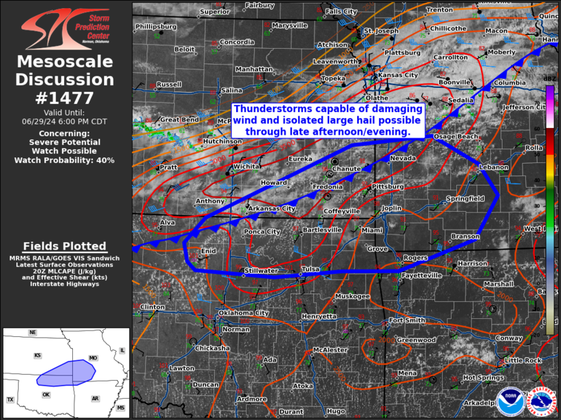
   SUMMARY...Thunderstorms capable of damaging wind and isolated large
   hail possible through late afternoon/evening.

   DISCUSSION...A southward drifting cold front extending from western
   Oklahoma northward into Kansas and Missouri will be the focus for
   thunderstorm development through the late afternoon and evening.
   Daytime heating has led to temperatures in the upper 90s to 100s and
   MLCAPE 3000-4000 J/kg across much of north-central Oklahoma into
   southern Kansas. In this region, clusters of towering cu can be
   observed. Consensus from CAM guidance suggests convective initiation
   occurring sometime between 21-00z along and near the cold front.
   Storm mode is expected to be cellular to small clusters, spreading
   east-southeastward through the evening. Deep layer shear is
   generally weak, with the best shear on the cool side of the
   boundary. This will support damaging wind as the main threat, though
   isolated hail will be possible. Trends will be monitored for watch
   potential late this afternoon/evening.

   ..Thornton/Gleason.. 06/29/2024

   ...Please see www.spc.noaa.gov for graphic product...

   ATTN...WFO...LZK...SGF...EAX...TSA...TOP...ICT...OUN...

   LAT...LON   36209523 36109650 36179797 36319813 36589819 36979781
               38109504 38249352 37809264 37329229 36659273 36209418
               36209523
|
|
|
Top/All Mesoscale Discussions/Forecast Products/Home |
|


