| Mesoscale Discussion 147 | |
| < Previous MD | |

|
|
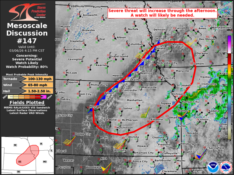
   Mesoscale Discussion 0147
   NWS Storm Prediction Center Norman OK
   0150 PM CST Fri Mar 06 2026

   Areas affected...central/northeast KS...southeast NE...southwest
   IA...and northwest MO

   Concerning...Severe potential...Watch likely

   Valid 061950Z - 062215Z

   Probability of Watch Issuance...80 percent

   SUMMARY...Monitoring for increasing severe potential this afternoon.
   Initial threat should be large hail and damaging winds, with a
   gradually increasing tornado threat. A watch issuance is likely.

   DISCUSSION...Increasingly agitated boundary-layer cumulus is evident
   over north-central KS into southeast MO -- within a zone of
   low-level confluence immediately ahead of a cold front. Continued
   diurnal heating amid lower 60s dewpoints should erode remaining
   inhibition and favor isolated storm development over the next couple
   hours. Around 1000 J/kg MLCAPE and 50-60 kt of effective shear will
   promote storm organization, though generally weak large-scale
   forcing for ascent casts uncertainty on individual storm longevity
   initially. Nevertheless, this environment will favor discrete
   supercells with a risk of large hail and damaging gusts. With time,
   storms will spread/develop east-northeastward, where sheltered
   boundary-layer moisture and larger clockwise-curved hodographs
   (aided by a 50-kt low-level jet sampled by TOP 18Z sounding) will
   favor an increasing tornado risk later this afternoon into tonight.

   While timing of thunderstorm development/maturation remains
   uncertain, current thinking is that a watch will likely be needed
   this afternoon.

   ..Weinman/Guyer.. 03/06/2026

   ...Please see www.spc.noaa.gov for graphic product...

   ATTN...WFO...DMX...EAX...OAX...TOP...ICT...GID...DDC...

   LAT...LON   40129754 40569695 41119640 41449597 41599526 41579447
               41289398 40549379 39939399 39039492 38309623 37989703
               37849769 37929829 38109877 38319905 38889911 39419874
               39869804 40129754

   MOST PROBABLE PEAK TORNADO INTENSITY...100-130 MPH
   MOST PROBABLE PEAK WIND GUST...65-80 MPH
   MOST PROBABLE PEAK HAIL SIZE...1.50-2.50 IN
|
|
|
Top/All Mesoscale Discussions/Forecast Products/Home |
|
Source link