| Mesoscale Discussion 1469 | |
| < Previous MD | |

|
|
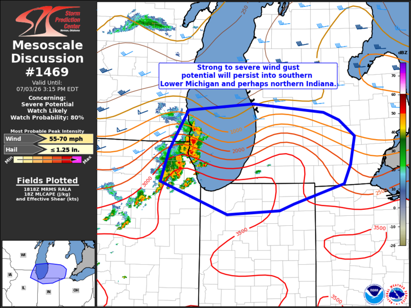
   Mesoscale Discussion 1469
   NWS Storm Prediction Center Norman OK
   0120 PM CDT Fri Jul 03 2026

   Areas affected...Southern Lower MI into northern IN

   Concerning...Severe potential...Watch likely

   Valid 031820Z - 031915Z

   Probability of Watch Issuance...80 percent

   SUMMARY...Strong to severe thunderstorms are possible this afternoon
   across southern Lower Michigan into northern Indiana. A severe
   thunderstorm watch is likely as as damaging wind risk could
   accompany this activity.

   DISCUSSION...A cluster of storms over northeast IL/southeast WI is
   likely to persist as these storms cross Lake Michigan. A strong
   instability gradient is oriented west to east across southern MI.
   Stronger westerly flow is mainly confined to areas in the wake of
   the cluster of storms and further north across Lower MI, somewhat
   displaced from the better instability. This results in some
   uncertainty regarding how organized convection will continue to be.
   Nevertheless, ample instability will support continued strong
   convection capable of local wind damage, and a severe thunderstorm
   watch will likely be needed soon.

   ..Leitman/Hart.. 07/03/2026

   ...Please see www.spc.noaa.gov for graphic product...

   ATTN...WFO...DTX...IWX...GRR...LOT...MKX...

   LAT...LON   43068784 43178627 43018456 42878420 42598383 42088394
               41748409 41388529 41278563 41208689 41778849 42348829
               43068784

   MOST PROBABLE PEAK WIND GUST...55-70 MPH
   MOST PROBABLE PEAK HAIL SIZE...UP TO 1.25 IN
|
|
|
Top/All Mesoscale Discussions/Forecast Products/Home |
|
Source link